Welcome to the great ISRAELI REAL ESTATE EVENT Coming to the USA and Canada


Inquiry: How should the "World" react to this event that goes against International Humanitarian Law #50 and #51?
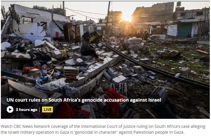
LIVE: ICJ orders Israel take measures to prevent acts of genocide in Gaza
By Published On 26 Jan 2024 Aljazeer
International Court of Justice said it won't throw out case on the main genocide question
CBC Thomson Reuters ·
Concepts of Geographic Thinking: Geographic Perspective, Patterns and Trends, Interrelationships, Spatial Significance
Internal Court of Justice Here’s a quick recap of the ICJ ruling:- The court says it has jurisdiction to rule in the case.
- The court orders Israel to take measures to prevent acts of genocide in the Gaza Strip, must report back in one month.
- The court says Israel must prevent and punish incitement to genocide in the Strip.
- The court says Israel must allow humanitarian aid into the Strip.
- The court obliges Israel to take more measures to protect Palestinians but does not order it to end military operations in the Strip.
What next?Inquiry: What might be needed for all sides to come up with an agreement that is lasting?Activity: Before starting it is important to understand what Internal Humanitarian Law is as well as the rules of war and to understand the meaning of genocide. Watch the Red Cross video What are the Rules of War? | The Laws of War | ICRC . Now conduct an issue analysis to better understand the stakeholders (eg. Palestine and their resources, Israel and their resources) and their values and beliefs. Understand how states might be held accountable to the ICJ. Create a spatial journal of the countries and events that have taken place over the years that has led to state the region is in now. With your issue analysis completed, create a story map that presents a possible solution to this issue and share it with individuals and organizations that might have influence.
- The court says it has jurisdiction to rule in the case.
- The court orders Israel to take measures to prevent acts of genocide in the Gaza Strip, must report back in one month.
- The court says Israel must prevent and punish incitement to genocide in the Strip.
- The court says Israel must allow humanitarian aid into the Strip.
- The court obliges Israel to take more measures to protect Palestinians but does not order it to end military operations in the Strip.
Ford vows to return land to the Greenbelt. That's a 'victory' for Hamilton, says councillor
Inquiry: Where might the land developers get their projected profit of 8.2 billion dollars now that the government put the speculated land back into the untouchable Greenbelt? How might the Conservative Government pay for the reversal of their plans to develop the Ontario Greenbelt?
Activity: Collect data on the Ontario Greenbelt and the projected land that was to be developed. Create a spatial journal of the land to be developed by developers that the Ford Government has connections with. Gather data on how much the land was purchased for and how much profit these developers were going to make if they were actually allowed to build on the protected land.

How might land developers make their projected profits now that they can not build there? Conduct an issue analysis and the Greenbelt timeline to help develop an action plan to understand how governments pay for projects that get cancelled. Communicate your solution via story map to ensure that that take taxpayer is not on the hook for the project profit loss by the new greenbelt land owners.
Vatican repudiates Doctrine of Discovery in response to demands from Indigenous people
· The Associated Press ·
California, Western Drought Update: Prolific Snowpack, Rising Reservoirs, But More Still Needed
 Concepts of Geographic Thinking:Inquiry: How might drought conditions impact communities? What might communities have to do to get access to the water they may need in the future?
Activity: Collect data on the water level of Lake Mead, Lake Powell, and Great Salt Lake. Create a spatrial journal to show how the water levels have changed over time and highlight the counties connected to theses reservoirs. Use the issue analysis to review where communities impacted by the drop in water levels in these three lakes get water and what issues new source may cause. Create an action plan that can help address the issue of decreased, long term, water levels in these lakes and propose a possible solution and communicate via story map.
Glaciers in the Antarctic Peninsula are Moving Faster During the Summers
Caitlin Dempsey | | Glaciology


“Monumental” nuclear fusion milestone achieved in the U.S

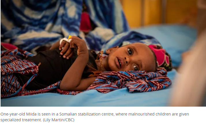
Somalia on the brink of another brutal famine, with children bearing the brunt

Concepts of Geographic Thinking: Patterns and Trends, Geographic Perspective, Spatial Significance
Inquiry: Why might many Americans suggest that "What stops armed bad guys is armed good guys" Ted Cruz even though only 1.2% of all incidents are solved by civilians? What might be needed to influence change regarding this attitude?
Concepts of Geographic Thinking: Patterns and Trends, Geographic Perspective, Spatial Significance
Inquiry: Collect data on American active short events. Map out using ArcGIS Online to show where these events are taking place to determine spatial significance. Conduct an issue analysis to better understand perspective of the issue. Determine what might need to be done and communicate potential solution to the issue in a story map. Be sure to share ideas with appropriate stakeholders.
COP27 closes with deal on loss and damage: ‘A step towards justice’, says UN chief

12.5 per cent of Sask. population is now immigrants: 2021 census
Climate change has broad effects on health-care systems, medical journal says Bob Weber · The Canadian Press ·
Why Iranian women are burning their hijabs after the death of Mahsa Amini
npr 

Concepts of Geographic Thinking: Geographic Perspective, Interrelationships
Inquiry: What might be needed to improve women's rights in Iran and the rest if the World? How will countries, particularly ones that have Supreme Court laws for taking away the right to an abortion, condemn women rights violations?
Activity: Collate data on women's right violations from around the world to determine a pattern. Gather data on the number of women that might die because of limited access to abortion. Examine at the statistics of the issue. Conduct an issue analysis to understand the stakeholders position on the issue. Create a choropleth spatial journal to determine regions of the world to create a visual of the issue. Develop an action plan to address the issue and communicate the results via story map to create change.
Kwanlin Dün First Nation in
Yukon is trying to figure out
where the Chinook salmon are
Sep 06, 2022 Chinook salmon at crisis levels says First Nations in Yukon.
 Concepts of Geographic Thinking: Patterns and Trends, Interrelationships
Inquiry: Why might the Chinook Salmon in the Yukon be at their lowest levels ever? How can society insure that the species does not become extinct. What might the impacts be on the populations that rely on this resource?
Activity: Gather data on the chinook stock. Examine possible human activity that might impact the fish. Conduct an issue analysis to gain further insight into the stakeholders that are apart of the issue. Create a spatial journal to show where possible impact location may be. Develop an action plan on how to address the issue and communicate the solution via story map. You may also want to create a survey123 and share with groups to create an inventory of the fish. This can be added to your spatial journal.
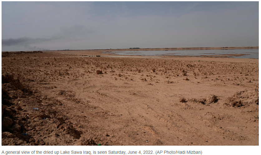
'The end of days is near': Iraq's Lake Sawa dries up amid water crisis
 Concepts of Geographic Thinking: Spatial Significance, Patterns and Trends, Interrelationships.
Inquiry: What might be needed to bring back the lake before over exploitation? How might the disappearance of the lake impact communities?
Activity: Conduct an issue analysis of the stakeholders impacting the Sawa Lake. Create a spatial journal outlining the location of the stakeholders to provide a visual of the problem. Develop an action plan to help address the issue of this water crisis and communicate via story map.
Fears for Taiwan as China lays groundwork for its own ‘special military operation’
Xi Jinping signs directive allowing for ‘non-war’ uses of the military – a tactic similar to that used by Russia before it invaded Ukraine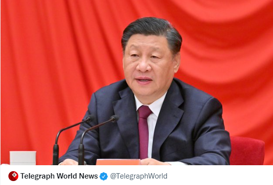
Concepts of Geographic Thinking: Geographic Perspective, Spatial Significance, Interrelationships
Inquiry: Why might China "want" Taiwan? How might other countries react if China does invade Taiwan? Could this lead to another Russia/Ukraine type conflict?
Activity: Collect evidence of China's interest in Taiwan. Analyze the data to understand why China wants to take Taiwan back. Examine China's' relationship with other countries in the area, the South China Sea. Conduct an issue analysis of the situation. Create a spatial journal to highlight the situations in the area. Determine next steps for the relationship between China and Taiwan and communicate the results using story map.
Pacific season’s 1st hurricane aims at Mexico tourist zone
Mon., May 30, 2022
 Concepts of Think: Spatial Significance, Patterns and Trends
Inquiry: Why might this area get hit with hurricanes? How might this hurricane seasons be different from the past ones?
Activity: Use the Geographic Inquiry Model collect and organize hurricane data. Examine weather patterns related to hurricanes. Create a spatial journal of past hurricanes to examine for patterns and make predictions on how this seasons may be different from past season. Explain why this might be happening and communicate in a story map.
Why many people in India aren't condemning Russia's invasion of Ukraine
Inquiry: How might India benefit from not condemning Russia's invasion of Ukraine? How might countries that do condemn the invasion dialogue with India in the future?
Activity: Collect evidence of the relationship between India and Russia. Gather data on what other countries might be able to do to move India away from Russia. Create a spatial journal of the stakeholders and outline their positions so the data can be reviewed. Conduct an issue analysis to outline the stakeholders involved. Collect data on what might be needed to support India's move away from Russian influence. Devise an action plan to support this move move away from Russian influence. Create a story might that might be used to show how India might be able to move away from the Russian influence. and create a story map to communicate results.

The hard truths of climate change — by the numbers
NATURE: Current issue
A family eats near a coal-fired power plant in China. Coal supplies nearly 60% of China’s energy, and the country is using more of the fuel, but renewable energy is growing at a faster rate. Credit: Adam Dean/PANOS Concepts of Geographic Thinking: Interrelationships, Spatial Significance, Patterns and Trends, Geographic Perspective
Inquiry: Why might some of the least developed countries be able to meet their Paris accord numbers and the developed countries struggle?What needs to be done to ensure countries meet their Paris accord numbers? What might happen if they don't
Activity: Examine the Paris Accord to understand the Global goals. Examine how countries are aiming at meeting their goals of the Paris agreement. Conduct an issue analysis of the top greenhouse gas emitters to better understand why they continue on their current path. Create a spatial journal of key players and influencing data. Develop an action plan to help countries meet their Paris accord numbers and help ensure a safe world in the future. Create a story map to communicate the action plan.
The EU can simultaneously end dependence on Russia and meet climate goals
- EDITORIAL
Inquiry: What might be needed to accelerate the EU's move away from Russian oil and gas? How might other countries follow this trend?
Activity: Gather evidence of the impacts of moving away from fossil fuels. Conduct a cost/benefits analysis of EU moving away from Russian oil and gas. Conduct an issue analysis and create a spatial journal of the stakeholders. Create an action plan to guide countries away from oil and gas, specifically EU countries and create a story map to communicate results.
Amid the Ukraine crises, the world must not turn its back on others in need By Mon., April 4, 2022

Concepts of Geographic Thinking: Geographic Perspective, Patterns and Trends, Interrelationships, Spatial Significance
Inquiry: How might the United Nations simultaneously address the humanitarian issues happening in other parts of the World?
Activity: Gather information highlighting humanitarian issues around the world? Determine stages of a humanitarian crisis so they might be identified early to help prevent them from happening in the first place. Conduct an issue analysis to clarify the roles and views of stakeholders. Create a spatial journal to identify locations around the world that might be sliding into a humanitarian crisis. Create a story map to communicate to organizations and politicians strategies that could be used to help reduce the human impact.
Concepts of Geographic Thinking: Geographic Perspective, Patterns and Trends, Interrelationships, Spatial Significance
U.N. chopper crashes in eastern Congo with 8 aboard, army blames rebels

Global Conflict: Crisis Watch
These are serious questions that need answers sooner than later to reduce the Human and Environmental impacts of such a conflict. With the world focused on Ukraine and how to support the 40 million people from such a threat what other severe conflicts might be overlooked? The situation the World finds itself in now with the escalation in Ukraine could be considered to be similar to the situation that lead to the genocide/ethnic cleansing that took place in the former Yugoslavia between 1992 and 1995 which overshadowed the Rwandan genocide. Could another "Rwanda" take place because the World is so focused on Ukraine. How can these types of conflicts be prevented. Who is able to help Ukraine and other countries in similar crisis situations that are going on right now from becoming the next genocide?
 Concepts of Geographic Thinking: Geographic Perspective, Spatial Significance, Patterns and Trends, Interrelationships
Inquiry: How can the Western powers help Ukraine and stop the Russian invasion and support other conflict regions that may need help also?
Activity: Conduct a Geographic Inquiry in the crisis in Ukraine. Collect data to gain a historical perspective of the conflict. Gather information on other global crisis's. Identify which crisis may lead to a conflict similar to the Ukraine - Russia crisis. Conduct and issue analysis to help understand the crisis. Create a spatial journal to map out what is where? Why there? and help determine the Why care? (Geographic definition). Develop an action plan that may help support Ukraine and other areas that are under threat. Produce a story map to communicate results to help create a better world.
Canada Opens Blockaded Bridge, but in Ottawa, Truckers Won’t Budge
Published Feb. 13, 2022, The New York Times
 Concept of Geographic Thinking: Geographic Perspective, Patterns and Trends, Interrelationships, Spatial Significance
Inquiry: Why might police in Ottawa choose not to do their job and remove the protesters like other parts of the Province? How might this action or lack of action impact a communities trust in the police institution?
Activity: Conduct an issue analysis to understand the stakeholders and their views relating the the "Trucker" protest in Ottawa. Collect evidence of law enforcement action or in action during other protest? Create a spatial journal to examine how location may play a role in how law enforcement react to protests. Create a story map to communicate the findings of the research conducted.
Published Feb. 13, 2022, The New York Times
Survey shows these Canadian cities have lost green spaces amid urbanization
By Posted February 1, 2022Inquiry: How might this pattern be reversed? What might government and industry do to ensure green space does not reduce even more?
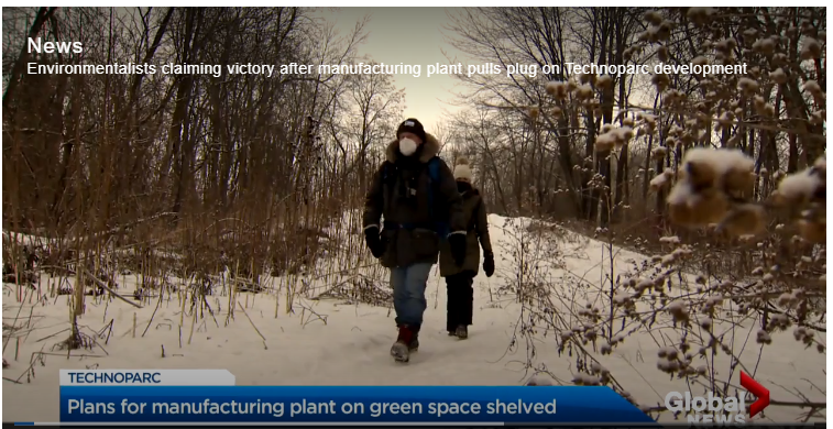
Activity: Collect data on green space in Canadian cities. Analyse data to by conducting an issue analysis to understand how and why cities depend on green space. Create a spatial journal to show the patterns and trends of this issue is happening then create a story map to describe the interrelationships required to develop solutions to this problem.
The global education crisis – even more severe than previously estimated

Ontario veering off track from its climate change targets, internal forecasts reveal.
· CBC News ·  Concepts of Geographic Thinking: Interrelationships, Geographic Perspective
Inquiry: What should Ontario do to meet carbon emission targets? why is this Government not fulfilling their obligations in fight Climate Change? How might Canada meet its environmental targets if Provinces do not do their part?
Activity: Use the geographic inquiry model to collect and organize data relating to environmental targets. Analyze the data to determine the potential success of Ontario's Made in Ontario Environmental Plan. Conduct an issue analysis to better understand the roles and position of stakeholders. Create a spatial journal to show where in Ontario environmental impacts maybe felt. Determine a possible plan of action that might bring Ontario back on course to meet their environmental targets and communicate it via story map to an appropriate audience.
B.C. declares state of emergency in wake of devastating flooding, mudslides Bridgette Watson, Akshay Kulkarni · CBC News · 

Livable Wages in Ontario 2021 by CRAIG PICKTHORNE

B.C. forests minister introduces bill to overhaul forest practices The Canadian Press OCTOBER 20, 2021

Coca-Cola, Pepsi and Nestlé named top plastic polluters for third year in a row
By Karen McVeigh, The Guardian, adapted by Newsela staff

Extensions: Use survey123 to conduct an environmental audit of your community to determine the main source of pollution. Create a spatial journal to map out the data and then create a story map to communicate your findings to encourage change in your environment.
California oil spill legal fight likely to last years BRIAN MELLEY, LOS ANGELES,THE ASSOCIATED PRESS
Inquiry: Why might the legal battle take years when action is needed now to clean up and prevent further spills? How might oil companies working offshore improve the process to greatly reduce the chance of future spills?
Activity: Collect data and information on the oil company involved. Identify possible stakeholders/players involved in the recent oil spill off the coast of California. Conduct an issue analysis to gain insight into the stakeholders involved to start developing an action plan. Create a spatial journal mapping out the event for a visual representation. Develop an action plan to either 1) help direct the clean up or 2) help reduce the chance of this event happening in the future. How possible is it to reduce this type of event happening in the future given the track record of oil companies? Create a story map to communicate your findings.
Related material: California justice department to investigate enormous oil spill
Inquiry: Why might an earthquake of similar magnitude have widely varying outcomes? What might be needed to reduce the negative outcomes of earthquakes around the world?
Activity: Collect data on earthquake impacts. Create a spatial journal of earth quake activity. Collect data on how to have development that is earthquake resistant Conduct an issue analysis to gain an understanding of the stakeholders involved. Develop a plan to help areas that are at risk and communicate plan of action via story map to an appropriate audience.


M5.9 quake halts trains in Tokyo area; 32 injured
By MARI YAMAGUCHI

Inside your smartphone: analyzing the rare-earth elements By
 Concepts of Geographic Thinking: Spatial Significance, Interrelationships, Geographic Perspective
After Hurricane Ida, Oil Infrastructure Springs Dozens of Leaks
By Blacki Migliozzi and
Erin O’Toole recycles a Scheer-era false claim: No, thousands of asylum seekers haven’t crossed ‘illegally’ at Roxham Road
Wed., Sept. 15, 2021
Concepts of Geographic Thinking: Geographic Perspective, Patterns and Trends, Spatial Significance
Inquiry: Why might Mr. O'Toole feel he must recycle false information? How might asylum seekers be treated better by all Canadians? How might these false views regarding asylum seekers be rectified?
Activity: Collect data on asylum seekers to Canada. Conduct an issue analysis to identify and understand stakeholders views and beliefs in this issue. Create a spatial journal using data that represents differing views across Canada. Create a story map to communicate your results to Mr. O'Toole about asylum seekers and why they are not illegal and show how improving the immigrant experience could benefited Canadians..
Climate crisis: Scientists spot warning signs of Gulf Stream collapse Damian Carrington Environment editor Thu 5 Aug 2021 16.08 BST
Concepts of Geographic Inquiry: Interrelationships, Spatial Significance, Patterns and Trends,
Inquiry: How might the Gulf Stream collapse impact coastal communities in different regions of the world? How might the Gulf Stream collapse be prevented?
Activity: Follow the path of the Gulf Stream to collect data on coastal communities that are influenced by the Gulf Stream. Record data on the pattern of climate influences in these communities. Conduct an issue analysis to determine views on ow to deal with the potential collapse of the Gulf Stream. Create a spatial journal to highlight key areas and create a story map to share possible solutions.
Global trade’s recovery from COVID-19 crisis hits record high UNCTAD 19 May 2021

Concepts of Geographic Thinking: Geographic Perspective, Patterns and Trends, Interrelationships, Spatial Significance
Inquiry: How might this rebound in Trade impact populations around the world? What might be the impact to environments as trade increase globally?
Activity: Collect data regarding Trade in 2020-2021. Collect data on environmental impacts due to increase global trade. Create a spatial journal of locations that might be impacted the most with the increase in trade. Conduct a issue analysis to gain insight to different perspectives on the issue. Create a story map to communicate the results of the investigation and promote a possible change to ensure equitable benefits.
Concepts of Geographic Thinking: Geographic Perspective, Patterns and Trends, Spatial Significance
Concepts of Geographic Inquiry: Interrelationships, Spatial Significance, Patterns and Trends,
Concepts of Geographic Thinking: Geographic Perspective, Patterns and Trends, Interrelationships, Spatial Significance
Israel-Gaza: Fears of war as violence escalates BBC News

Concepts of Geographic Thinking: Geographic Perspective, Patterns and Trends, Spatial Significance, Interrelationships
Inquiry: What might be needed for the conflict between Israel and Palestine to end peacefully? How might excess force from Israel, a super power, over the developing state of Palestine be justified?
Activity: Gather data on the conflict. Conduct an issue analysis to gain greater insight into the long lasting conflict. Create a spatial journal to highlight significant places. Decide on how to best solve this issue or how to influence one side to refrain from using excessive force and communicate it a strategy via story map.
Concepts of Geographic Thinking: Geographic Perspective, Patterns and Trends, Spatial Significance, Interrelationships
On the shores of Georgian Bay, an Ontario boom town puts a sudden stop to development. Why? It says it’s running out of water By
Inquiry: How might development impact the environment? How might other cities/municipalities develop in the face increased impact on the environment?
Activity: Conduct an issue analysis to understand the different views with this issue. Create a Spatial Journal of key places in the issue. Discuss how these areas might be impacted. Determine a course of action that would benefit the community of Collingwood. Create a Story Map to communicate your findings.

‘We are witnessing a crime against humanity’: Arundhati Roy on India’s Covid catastrophe
 Concepts of Geographic Thinking: Interrelationships, Geographic Perspective, Spatial Significance
Inquiry: How can a government ignore the people that it represents? What might be needed for a government to respect all of their people? What role might multinational corporations play in the impact of COVID-19 in India and other countries?
Activity: Collect data regarding government policy on workers. Conduct an issue analysis to gain understanding of the different viewpoints. Create a spatial journal to show the distribution of workers in India and the multinational corporations they are working for. Create an action plan that the Indian government might be able to follow to help support their works. Create a story map to communicate your solution to the Indian government and the corporations in India.
Explore: Conduct research to see what other jurisdictions are doing to support the working class during the COVID -19 Pandemic. Is it enough to actually help the workers or does it just reinforce the statues queo of serving the elite? See Ontario's response to paid sick leave for workers, 3 days paid for by the taxpayers.
 Concepts of Thinking: Geographic Perspective, Interrelationships, Patterns and Trends, Spatial SignificanceInquiry: How might some Provinces proceed now that they are legally required to create their own carbon tax system if they do not want to follow the Federal Carbon Tax Plan? Why have some Provinces tried to make it hard for Canada to meets its Paris Accord targets by 2030?Action: Examine Canada's Paris Accord targets. Review the the strategies that Canada has committed to in achieving the targets. Conduct an issue analysis of the situation to better understand the values and beliefs of stakeholders involved in the situation. Create a spatial journal highlighting these stakeholders position. Make recommendations to the Provinces on how they should proceed to make sure the Paris Accord targets are meet by Canada and communicate this to the different levels of Government in a Story Map.
‘We are witnessing a crime against humanity’: Arundhati Roy on India’s Covid catastrophe
Inquiry: How can a government ignore the people that it represents? What might be needed for a government to respect all of their people? What role might multinational corporations play in the impact of COVID-19 in India and other countries?
Activity: Collect data regarding government policy on workers. Conduct an issue analysis to gain understanding of the different viewpoints. Create a spatial journal to show the distribution of workers in India and the multinational corporations they are working for. Create an action plan that the Indian government might be able to follow to help support their works. Create a story map to communicate your solution to the Indian government and the corporations in India.
Explore: Conduct research to see what other jurisdictions are doing to support the working class during the COVID -19 Pandemic. Is it enough to actually help the workers or does it just reinforce the statues queo of serving the elite? See Ontario's response to paid sick leave for workers, 3 days paid for by the taxpayers.
‘I Can Get Killed.’ A Leading Activist Talks About Her Role in the Fight Against Myanmar's Junta
BY ARIA CHEN
 CONCEPTS OF GEOGRAPHIC THINKING:INQUIRY: WHEN MIGHT OTHER COUNTRIES SUPPORT THE PEOPLE OF MYANMAR RESISTE THE COUP?ACTIVITY: COLLECT INFORMATION RELATING TO THE COUP. CONDUCT AN ISSUE ANALYSIS OF THE STAKEHOLDERS INVOLVED IN THE CONFLICT. CREATE A SPATIAL JOURNAL TO MAP OUT KEY EVENTS LEADING UP TO THE CONFLICT. DEVELOP A POTENTIAL SOLUTION AND COMMUNICATE VIA STORY MAP TO THE APPROPRIATE AUDIENCE, SAY THE UNITED NATIONS.
China’s attempt to conceal Uyghur genocide have ‘unravelled’: activist
 Concepts of Geographic Thinking: Geographic Perspective, Interrelationships, Patterns and Trends, Spatial Significance

Inside a 15-year dispute between doctors and farmers over a proposed racetrack in rural Alberta.
Kyle Bakx · CBC News · 
Concepts of Geographic Thinking: Spatial Significance, Geographic Perspective, Interrelationships
Inquiry: How might at risk species rebound in population if recreation developments happen in their habitat? How can a Federally protected species be at risk by a Provincial decision? How might the environment be protected if Federal and Provincial legislations do not equally value the environment?
Activity: Collect data on the Banks Sparrow in Canada to better understand how the bird is being impacted by human development. Gather data on existing raceways to determine the need for a new track. Examine data in the Federal strategy to support the Banks Sparrow. Conduct an issues analysis to fully examine the stakeholders. Create a spatial journal to identify significant areas and communicate your finds in a story map to be shared with others.
As polar vortex arrives, Canada logs coldest temperature in years.
Brooklyn Neustaeter CTVNews.ca Writer Concepts of Geographic Thinking:
Inquiry: How might the Polar Vortex influence weather across Canada?
Activity: Collect data about Canadian Polar Vortex. Conduct an issue analysis of the polar vortex to determine stakeholders views on the topic. Create a spatial journal to show the location of the polar vortex and create an action plan on how to deal with this weather phenomena and communicate via story map.
Can Wall Street help us find the true price of water?
· CBC News ·
Inquiry: How might Wall Streets commodifying of a local supply of water, which is also a human need, increase sustainable for all people?
Activity: Gather data on water supply and shortage and create a spatial journal to help show where the issue is happening. Conduct an issue analysis to better understand the stakeholders involved. Develop a position on what should happen to help reduce the Global Water Crisis and communicate via story map.

LETTER: Ontario’s conservation authorities under attack by Ford government By:

Concepts of Geographic Thinking: Spatial Significance, Geographic Perspective
Inquiry: How will the reduced function of Conservation Authorities in Ontario be impacted by this move by the Ontario Government? How will sensitive environmental areas be impacted? What can be done to protect the environmental sensitive areas under attack?
Activity: Conduct research about Bill 229 and some of the implications of the changes. Conduct an issue analysis to better understand the stakeholders involved. Create spatial journal using ArcGIS Online to identify areas at risk. Create a story map after the data has been analysed and a action plan has been created.
Concepts of Geographic Thinking: Spatial Significance, Geographic Perspective
State of Climate Services 2020 Report: Move from Early Warnings to Early Action.

Geographic Concepts of Thinking: Geographic Perspective, Spatial Significance, Interrelationships, Patterns and Trends
Inquiry: As the number and cost (human and dollar amount) of environmental disasters continue to increase what can be done to help all countries develop a Climate strategy that deals with Climate Change?
Task: Collect data on what countries around the world are doing to combat climate change. Gather data on what scientist suggest should be done to deal with climate change. Create a spatial journal to show how spatial significance may impact a country's plan as well as how geographic perspective influences the countries climate change agenda. Create a story map to communicate your findings
Where should lanes be closed for pedestrians and cyclists as the city comes back to life? We crunched the data
 Concepts of Geographic Thinking: Spatial Significance, Geographic Perspective, Interrelationships, Patterns and Trends
Inquiry: How might the Mayors office decide which streets would be idea to close for pedestrians.
Activity: Gather appropriate data that can be displayed in a spatial journal. Conduct an issue analysis of the data that can be used to support your decision. Create a story map to present to appropriate decision makers.
Getting started video
Students will convert xls files to csv so the data can get dropped off in ArcGIS Online.
Students will manipulate data by Classifying the data.

Mapping 2019-nCoV
Geography plays a large role in helping experts better understand COVID-19 by implementing the Geographic definition of What is where? Why there? and Why care? followed up with What to do?

Concepts of Geographic Thinking: Patterns and Trends, Spatial Significance, Interrelationships, Geographic Perspective.

We have 10 years to save Earth's biodiversity as mass extinction caused by humans takes hold, UN warns By Jessie Yeung, CNN
Updated 3:01 AM ET, Tue January 14, 2020
 Concepts of Geographic Thinking: Geographic Perspective, Interrelationships, Patterns and Trends, Spatial Significance
Inquiry: What might be needed to ensure that the next mass extinction does not take place?
Activity: Gather data on what factors may contribute to a species mass extinction. Understand how human activity may contribute to the 6th mass extinction. Gather data on what Governments and other stakeholders views regarding this mass extinction. Complete an issue analysis and create a spatial journal of the facts and views. Determine a plan action and communicate via story map.
Loudspeakers make dead coral reefs sound healthy and fish swim to them By Washington Post, adapted by Newsela staff Published 12/13/2019

Concepts of Geographic Thinking: Interrelationships, Patterns and Trends, Spatial Significance
Inquiry: How might the fish help bring back the coral to life? What might be required to bring the coral back to life?
Activity: Gather data about coral bleaching and dead coral and create a spatial journal to show where coral is at risk. Collect data on the impacts of coral sounds have on fish. Conduct an issue analysis to understand the different views involved and devise a plan of action to help bring the coral back to life and communicate your results via story map.
 Concepts of Geographic Thinking: Geographic Perspective, Interrelationships
Inquiry: Why might the United Nations have taken down it's page regarding Rwanda down?
Why is Rwanda missing from the list of countries that the United Nations was involved in?

source: United Nations: Shaping Our Future Together under Preventing Genocide
Activity: Gather data on the Rwandan Genocide. Conduct an issue analysis to understand the stakeholders involved. Create a spatial journal of the stakeholders involved in the Genocide, including the United Nations. Create a story map and publish it on social media so that the World does not forget about Rwanda even though the UN seems to have.


New map shows which parts of Canada lag on believing in climate change.
 Concepts of Geographic Thinking:
Inquiry: Why might different parts of Canada view Climate Change differently and how might these views be changed to represent the true threat of Climate Change?
Activity: Gather information on different industries in Canada. Collect data on impacts of Climate Change by region. Conduct and issue analysis to better understand the perspectives involved. Create an action plan that connects an communicates with people the importance of acting on climate change data via story map.

Up to 800 forestry jobs lost as Teal-Jones halts harvesting in southwest B.C.Dirk Meissner · The Canadian Press ·

Activity: Gather data on the Canadian lumber. Create a Spatial Journal indicating where the lumber industry is located in Canada. Create a Story Map to outline what might happen the Canada's limber industry in the future and suggest ways to ensure its sustainability moving forward.
'We don't want to be the next cancer village': Canada's plastic recycling dumped and burned overseas Eric Szeto, Katie Pedersen, David Common and Luke Denne · CBC News ·

Just one-third of the world's longest rivers remain free-flowing 

Inquiry: How might human interrelationship with the rivers impact sustainability?
Activity: Gather information on the the world largest rivers and human population to create a spatial journal. Examine how humans are using the water. How might spatial significance impact how the water is used? Collect information on the stakeholders using the issues analysis. How might the stakeholders perspective influence sustainability of the river? From the geographic perspective develop a plan that may lead to better interaction along the river so that human activity is actually sustainable. Create a story map to communicate a possible solution.

Do we treat our soil like dirt? The effects of soil erosion By Dennis Dimick, National Geographic, adapted by Newsela staff
 Concepts of Geographic Thinking: Interrelationships, Spatial Significance
Inquiry: How might soil erosion impact different communities?
Activity: Gather data on contributing factors that may cause soil erosion. Create a spatial journal to record where the different types of factors might be found. Evaluate some methods that may reduce soil erosion and where they may work best, add this information to the spatial journal. Develop an action plan that might be useful in a community and communicate results via story map.

Sustainable fishing
Inquiry: How might fish stocks be protected so future generations have access to this resource?
Activity: Gather data on overfishing. Conduct an issue analysis to understand of geographic perspective of the stakeholders. Review sustainable fishing practices and create a spatial journal to show where they are. Develop a plan that might work better for the Canadian fishing industry and communicate via story map.


Life at the Arctic floe edge

What it’s like to raise children in the world’s most polluted capital
Annabelle Timsit, Reporter, Early Childhood Development, Quartz
 Geographic Concepts of Thinking: Interrelationships, Spatial Significance, Patterns and Trends
Inquiry: How might this situation be made better for the people of Ulaanbaatar, Mongolia, the world’s coldest capital city and one of its most polluted.
Activity: Determine the factors that have contributed to this situation. Create a spatial journal to show where the other most polluted places are found and observe for patterns that may emerge. Are there any trends that can be found? Conduct and issue analysis to develop an action plan that can address this situation so the residents may live with clean air. Communicate action plan via story map.

Inquiry: How might this situation be made better for the people of Ulaanbaatar, Mongolia, the world’s coldest capital city and one of its most polluted.
Drilling down into petroleum's impact on life on Earth
 Concepts of Geographic Thinking: Geographic Perspective, Spatial Significance, Interrelationships
Inquiry: How might a movement away from oil impact regions of the world?
Activity: Create a spatial journal of oil producing countries/regions of the world. Conduct an issue analysis to determine the stakeholders perspective of oil and how oil may impact the environment and the economy. Evaluate the issue from a Geographic Perspective to determine a course of action and communicate this via story map.

The Biggest Eruption of 2018 Was Not Where You Think NASA
 Concepts of Geographic Thinking: Spatial Significance, Patterns and Trends
Inquiry: Why might the release of Sulphur Dioxide into the atmosphere from a volcanic eruption be of concern?
Activity: Collect data on the impacts of sulphur dioxide in the atmosphere. Determine the connection between sulphur dioxide release and spatial significance by creating a spatial journal of volcano type and amount of sulphur dioxide release and observe for any patterns and trends. From a geographic perspective, how might these events, the release of sulphur dioxide into the environment, be of concern to stakeholders? Conduct an issue analysis to gain perspective and develop an action plan to deal with these types of events and communicate the results as a story map.
A bold new plan to tackle climate change ignores economic orthodoxy.
The Economist
Business and financFeb 5th 2019
 Concepts of Geographic Thinking: Geographic Perspective,
Inquiry: How might `going green`impact the US economy and economies of the world? Why are Canadians not wanting to "Go Green"? How might this view be changed?
Activity: Gather information on the environmental and economic impacts of "going green". Conduct an issue analysis to determine the values and beliefs of different stakeholders in going green discussion. Create a spatial journal that reflects the research of the different places that are going green. Develop a plan to help pursued other stakeholders that going green might be beneficial to them and their people and communicate via story map.

A bold new plan to tackle climate change ignores economic orthodoxy.
Concepts of Geographic Thinking: Geographic Perspective,Climate change will change the colour of Earth’s oceans by the end of the 21st century
Climate Action: Rachel Cooper
 Concepts of Geographic Thinking: Interrelationship, Spatial Significance, Geographic Perspective
Inquiry: How might the colour change of the oceans impact human populations? How might communities prepare for this future?
Activity: Gather data on ocean temperatures impacts and locations. Conduct an issue analysis to identify stakeholders and to understand their position. Create a spatial journal of stakeholders and local water temperatures. Develop a possible reaction to this situation and communicate it via story map.
Satellites saw rapid Greenland ice loss
BBC news

Inquiry: How might this ice loss impact communities in the north and south? What action to fight climate change might be the best to help reduce this ice loss?
Activity: Gather data on ice loss in Greenland and the results of the ice loss. Create a spatial journal of communities in the region. Conduct an issue analysis to develop an action plan to support communities if current trends continue. Communicate results in a Story Map.

These are the biggest risks facing our world in 2019
World Economic Forum
 Concepts of Geographic Thinking: Interrelationships, Spatial Significance, Patterns and Trends, Geographic Perspective
Inquiry: What might be the solutions to these risks?
Activity: Collect data of Global Risks and create a spatial journal to show where climate issue are most prevalent. Conduct an issue analysis to gain insight into the views of the stakeholders. Determine which issue should take priority and then develop an action plan that can be communicated via story map.
Donald Trump plans to pull American troops out of Syria The Economist
Inquiry: How will communities in the region be impacted by the Americans decision to withdraw troops from Syria?
Activity: Gather information on the stakeholders in this conflict. Conduct an issue analysis to better understand the positions of the stakeholders. Create a spatial journal of the stakeholders and the land they occupy. Make predictions that might happen as a result of this withdraw and develop a plan to might minimize the impact on communities as a result of the withdrawal. Communicate your results via story map and communicate to the appropriate audience.

Donald Trump plans to pull American troops out of Syria The Economist

Canada is a tinderbox for populism.
Dec 3, 201

Inquiry: How might populism impact Canadian communities?
Activity: Collect data on current issues in Canada and conduct an issue analysis to determine how people and the parties alien with them. Gather information on what leaders are saying to determine if they are solving the problem or saying what people want to hear. Create a spatial journal identifying where the issues are and add to it what is being said observe for patterns and trends. Create a story map to communicate your finds following the geographic definition: What is where? Why there? Why care? and What next?

Canada's must assert sovereignty over the Arctic while there's still time
National Post, November 2, 2017
Senator Dennis Patterson: As has been the case throughout history, sovereignty often relies on the realpolitik principle of “use or lose it"

Inquiry: How might Canada maintain sovereignty of the Arctic?
Activity: Conduct research on the Laws of the Sea to determine a baseline understanding of land/sea rights. Conduct an issue analysis of the countries and communities in the region. Create a spatial journal to help develop plan of action and communicate via story map to an appropriate audience.

Indonesia Has Declared a State of Emergency as Borneo Oil Spill Spreads TIME

Inquiry: What is required to ensure events like this do not happen in the future? Who might be responsible for this event and how might they be held accountable? What might accountability look like in this event?
Activity: Gather data on the spill and and create a spatial journal of the event. Conduct an issue analysis to develop a structure of responsibility. Create an action plan to deal with the situation and create a story map to communicate your results.

If we don’t protect the ocean, humanitarian disaster awaits
 Concepts of Thinking: Geographic Perspective, Interrelationships
Inquiry: What might be need to engage stakeholders enough to take action on this issue that will evoke real change?
Activity: Gather resources regarding ocean/water pollution. Create a spatial journal of regions and industries that contribute the most to this global problem. Conduct an issue analysis to evaluate stakeholders positions and develop a plan of action that may solve the problem. Create a story map to convey the potential solution.

Ukraine demands Russia release seized ships as tensions build The Associated Press ·
 Geographic Thinking: Interrelationships, Patterns and Trends, Spatial Significance, Geographic Perspective
Inquiry: Why might Russia want to stop Ukraine ships in international waters? How should the rest of the World react to the Russian aggressions?
Activity: Gather information of the region. Conduct an issue analysis to better understand the stakeholders in this issue. Produce a spatial journal to locate contributing events. Develop a plan of action and communicate it to an appropriate audience via story map.

Oil vessel off the Newfoundland coast spills 250,000 litres of crude Malone Mullin · CBC News · Nov 16, 2018

Concepts of Thinking: Interrelationships, Geographic Perspective, Spatial Significance, Patterns and Trends
Inquiry: What might be needed to ensure these "accidents" stop happening? How will communities be impacted by future drilling plans?
Activity: Gather data on oil drilling off the coast of Newfoundland and Labrador to create a spatial journal. Collect information on the stakeholders to conduct an issue analysis. Develop an action plan to communicate a potential solution and create a story map to communicate the result.
Related stories:
All offshore oil rigs shut down in N.L. after Husky Energy spill: board

Poor weather prompts temporary shutdown of all N.L. offshore rigs
#Travelgoals: why Instagram is key to understanding millennial tourism

Inquiry: How might increased Instagram use impact travel/tourist destinations?
Activity: Gather data on the top destination before instagram (April 2012) and create a spatial journal. Collect data on sites that instagram has made popular and add this to your spatial journal. Observe for patterns and trends. How might spatial significance impact the popularity? Conduct an issue analysis of to develop a plan of action to maintain the location. Create a story map to communicate your results.

False statements on migrant caravan spark political controversy newsela
 Concepts of Geographic Thinking: Geographic Perspective, Interrelationships
Inquiry: What role should social media and governments play in managing this form of communication? How can individuals protect themselves from false information?
Activity: Conduct an issue analysis of the situation. Determine where false information is being transmitted. Is there any spatial significance to these sources? Create a spatial journal to identify where false information is coming from and who is trying to stop it. Create a story map to communicate strategies to help deal with the spread of false information.

These will be the world's megacities in 2030 World Economic Forum
 Concepts of Geographic Perspective:
Patterns and Trends, Spatial Significance
Concepts of Geographic Perspective:
Patterns and Trends, Spatial Significance
Inquiry: What might be the global impacts of these mega cities
Activity: Gather information on mega cities. Create a spatial journal of the cities to help determine spatial significance. Conduct an issue analysis to help develop a plan to help reduce the environmental impacts of mega cities and communicate via story map.

Europe’s dirty air kills 400,000 people every year
 Concepts of Geographic Thinking:
Inquiry: How might the issue of air pollution be better addressed so that 400, 000 people do not need to die? Where else might people be a risk?
Activity: Conduct an issue analysis to help develop a plan of action. Conduct research in to Europe's air pollution and around the world. Catalogue current strategies to deal with air pollution. Determine areas that most at risk and create a spatial journal. Develop an implementation plan that can be communicated via story map.
How to dispose of human waste on Mount Everest Oct 25th 2018 | GORAKSHEP, The Economist
Inquiry: How might human waste be managed in a sustainable manner on the mountain?
Activity: To develop an understanding of the issue conduct an issue analysis. Then conduct some research into human waste disposal methods. Determine a method the would be appropriate for the spatial significance of the region and map out the most appropriate location in a spatial journal. Develop a plan to help implement the appropriate method that will help maintain the ecological sensitivity of the area. Communicate results via story map.

How to dispose of human waste on Mount Everest Oct 25th 2018 | GORAKSHEP, The Economist

Inquiry: How might human waste be managed in a sustainable manner on the mountain?
Activity: To develop an understanding of the issue conduct an issue analysis. Then conduct some research into human waste disposal methods. Determine a method the would be appropriate for the spatial significance of the region and map out the most appropriate location in a spatial journal. Develop a plan to help implement the appropriate method that will help maintain the ecological sensitivity of the area. Communicate results via story map.
Explosion at Saint John refinery raises questions over how information was shared with public By Andrew Cromwell
Inquiry: How might this explosion impact communities?
Activity: Gather information on the oil refinery to determine the life cycle of the oil coming into the refinery. Create a spatial journal to identify some of the location Irving Oil gets it's resource from. Conduct an issue analysis and develop a strategy to help deal with future issue regarding oil transportation. Communicate results via story map.

 Concepts of thinking: Patterns and Trends, Spatial Significance
Inquiry: What might the distribution of money be over the next 30 years or so? What might be the equivalent to a $1.00 day in 1975 be at today's market considering inflation?
Activity: Conduct some research on inflation to determine what $1.00 dollar in 1975 would be in today's market. Determine what people might be able to purchase by country. Conduct an issue analysis to determine a possible solution the the lack of monetary distribution. Create a spatial journal to observe and patterns and predict the future trends. Communicate suggestions via storymap.

New Eye Means Hurricane Florence May Get Stronger Before Slamming into the US
By |
 Concepts of Thinking: Geographic Perspective, Spatial Significance
Inquiry: What might be needed to help bring this conflict to an end that will last?
Activity: Conduct an issue analysis to collect data on the stakeholders. Create a spatial journal of events and stakeholder interests. Develop a potential solution to the issue and share via story map.
The IEA’s first Global Energy and CO2 Status Report – released in March 2018 – provides a snapshot of recent global trends and developments across fuels, renewable sources, and energy efficiency and carbon emissions, in 2017.
 Concepts of Thinking: Patterns and Trends
Inquiry: How might this trend impact communities around the world .
Activity: Conducta an issue analysis to gain insight into the stakeholders perspective. Create a spatial journal to show where some impacts may be felt. Create a story map to communicate findings.


Inquiry: What might be needed to help bring this conflict to an end that will last?
Activity: Conduct an issue analysis to collect data on the stakeholders. Create a spatial journal of events and stakeholder interests. Develop a potential solution to the issue and share via story map.
The IEA’s first Global Energy and CO2 Status Report – released in March 2018 – provides a snapshot of recent global trends and developments across fuels, renewable sources, and energy efficiency and carbon emissions, in 2017.

Inquiry: How might this trend impact communities around the world .
First yellowtail farms to be ASC certified are Japanese
 Concepts of Thinking: Geographic Perspective, Interrelationship
Inquiry: How might this certification impact ecosystems?
Activity: Research fish farms and their impacts on the environment. Create a spatial journal of fish farms. Conduct an issue analysis of the stakeholders to develop a plan to create sustainable development of fish farms. Communicate plan via story map.

1494: TREATY OF TORDESILLAS
 Concepts of Thinking: Geographic Perspective, Spatial Significance
Inquiry: More than 50 million Indigenous people were negatively affected by this treaty, how might this situation be corrected for their ancestors?
Activity: Collect info on the problem and conduct an issue analysis of the stakeholders. Create a spatial journal of the stakeholders. Develop a solution that helps the people whose ancestors were not taken into consideration at the time of colonization. Communicate solution via story map to an appropriate audience.

2017 Was Another Record-Busting Year for Renewable Energy, but Emissions Still Increased EMMA FOEHRINGER MERCHANT JUNE 04, 2018
 Concepts of Thinking: Patterns and Trends, Interrelationships, Geographic Perspective, Spatial Significance
Inquiry: Why might emissions continue to increase even as renewable energy use is increasing?
Activity: Create a spatial journal of renewable energy and nonrenewable energy use. Conduct an issue analysis to help develop a plan of action to get more countries reducing nonrenewable energy sources. Communicate results via story map

Guatemala's Fuego volcano erupts, killing 33 and injuring hundreds
 Concepts of Thinking: Interrelationships, Spatial Significance, Geographic Perspective
Inquiry: What made this eruption so deadly? How might the communities impacted move forward after this event?
Activity: Gather data on effects of volcanoes . Conduct an issue analysis of the stakeholders involved to help develop a plan of action. Create a story map to communicate the results of the research.

Activity: Gather data on effects of volcanoes . Conduct an issue analysis of the stakeholders involved to help develop a plan of action. Create a story map to communicate the results of the research.
The 2018 Atlas of Sustainable Development Goals: an all-new visual guide to data and development 
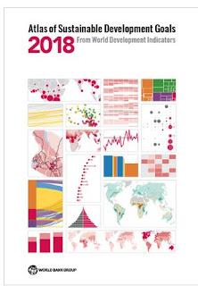
Inquiry: How might the World meet these goals?
Activity: Gather information on countries and what they are doing regarding the SDGs. Create a spatial journal of the information to show how countries are doing. Conduct an issue analysis to develop a plan that might help all countries meet their goals. Communicate results via story map.

As Tigers Become Rarer, Poachers Are Targeting Lions National Geographic
 Concepts of Thinking: Geographic Perspective, Interrelationships
Inquiry: How might the lion be saved from extinction?
Activity: Gather data on the range of the lions past and present to create a spatial journal. Conduct an issue analysis of the stakeholders impacting the lions. Develop a plan of action and communicate via story map.

This Refuge May Be the Most Contested Land in the U.S. National Geographic

Concepts of Thinking: Spatial Significance, Geographic Perspective, Interrelationships
Inquiry: How might the US oil extraction impact Canadians?
Activity: Gather data on fossil fuels in the region and create a spatial journal. Conduct an issue analysis to gain insight on the stakeholder. Develop a plan to deal with potential impacts and communicate via story map.
Russia’s role in shooting down an airliner becomes official The Economist

Concepts of Thinking: Geographic Perspective, Interrelationships
Inquiry: What should appropriate compensation be for this incident? How might this decision impact relationship of the stakeholders?
Activity: Create a spatial journal of the stakeholders. Conduct an issue analysis of the incident. Develop a potential resolution to this situation and communicate via story map.
The best idea in a long time: Covering parking lots with solar panels
 Concepts of Thinking: Patterns and Trends, Spatial Significance, Interrelationships
Inquiry: What might the impacts be with solar panel parking lots in Canadian?
Activity: Use Survey 123 to record data on parking lost in major cities in Canada as well as amount of sunshine in these places. Display results as a spatial journal. Conduct an issue analysis to develop a plan of action. Communicate plan of action via story map.

Russia’s role in shooting down an airliner becomes official The Economist

Concepts of Thinking: Geographic Perspective, Interrelationships
Inquiry: What should appropriate compensation be for this incident? How might this decision impact relationship of the stakeholders?
Activity: Create a spatial journal of the stakeholders. Conduct an issue analysis of the incident. Develop a potential resolution to this situation and communicate via story map.
The best idea in a long time: Covering parking lots with solar panels

WHAT HAPPENS TO THE PLASTIC WE THROW AWAY?
Protests on Gaza’s border with Israel turn deadly

Middle East and Africa May 14th 2018| MALAKA The Economist
 Concepts of Thinking: Geographic Perspective, Patterns and Trends, Interrelationships, Spatial Significance
Inquiry: What might be needed to bring stability to this region?
Activity: Gather data on the conflict between Palestine and Israel. Create a spatial journal of the region. Conduct an issue analysis to determine the views of the stakeholders and then develop a possible solution. Communicate the possible solution via story map.

Black rhinos return to Chad 50 years after poaching wiped them out

Inquiry: What might be need to ensure this species thrives? What might be need to stop poaching of other animals?
Activity: Gather data on the Black Rhino and create a spatial journal. Conduct an issue analysis to determine the perspective of stakeholders involved. Develop a strategy to stop poaching and protect more species at risk and endangered. Communicate possible solution by story map.

The earthquake unleashed by Trump's departure from Iran nuclear deal By Tim Lister, CNN
 Concepts of Thinking: Geographic Perspective, Interrelationships
Inquiry: How might the US departure from the the Iranian nuclear deal impact stakeholders?
Activity: Create a spatial journal of the stakeholders in the deal. Conduct an issue analysis to gain further insight of the issue. Follow the geographic inquiry model to develop a potential action plan to help deal with this situation. Communicate via story map.
A smaller red wolf population might be easier to save, says federal agency
 Concepts of Thinking: Geographic Perspective, Interrelationships, Spatial Significance
Inquiry: Why might the agency that is designed to protect this critically endangered animal suggest few numbers are better? How might this impact communities?
Activity: Gather data on the red wolf. Create a spatial journal to show the range of the species past and present. Conduct an issue analysis to gain understanding of stakeholder. Evaluate the stakeholders views and develop a possible solution using the geographic perspective. Communicate view story map.
Plastic fibres found in tap water around the world, study reveals Damian CarringtonEnvironment editor
 Concepts of Thinking: Interrelationships, Spatial Significance
Inquiry: How might these plastics entered the system? What might the impact be of these plastics?
Activity: Gather data on plastic fibers in water. Conduct an issue analysis to help develop a potential solution. Communicate result via story map and communicate results.

A smaller red wolf population might be easier to save, says federal agency

Inquiry: Why might the agency that is designed to protect this critically endangered animal suggest few numbers are better? How might this impact communities?
Activity: Gather data on the red wolf. Create a spatial journal to show the range of the species past and present. Conduct an issue analysis to gain understanding of stakeholder. Evaluate the stakeholders views and develop a possible solution using the geographic perspective. Communicate view story map.
Plastic fibres found in tap water around the world, study reveals Damian CarringtonEnvironment editor

The worst age for women to have kids in terms of career
Inquiry: How might this wage discrepancy best be reduced?
Activity: Conduct research to determine the wage gap in several countries of the world and create a spatial journal. Conduct an issue analysis to help develop a plan of action. Create a story map to communicate potential solution.

Could sprinkling sand save the Arctic's shrinking sea ice?

Inquiry: What might the result of spreading silica over the ice caps be? Are there alternatives that might be more practicile? How should communities proceed with the reduction of ice caps melting?
Activity: Gather data on ice caps melting. Create a spatial journal to identify locations of areas of concern, if there are any specific places. Conduct an issue analysis to compare potential solutions and determine the most appropriate solution. Communicate via story map.

UK may record hottest April day in almost 70 years

Canadian drug mule sentenced in Australia for cocaine cruise The Canadian Press

Inquiry: How might drug smuggling impact the Travel industry? Who really is the criminal and how should they be treated?
Activity: Gather data on where this type of smuggling takes place. Create a spatial journal indicating place of origin and destination. Conduct an issue analysis and develop a strategy to deal with this issue. Communicate your result to an appropriate audience via story map.

Renewables grew twice as fast as fossil fuels in 2017.
 Concepts of Thinking: Interrelationships, Geographic Perspective, Patterns and Trends, Spatial Significance
Inquiry: How might this trend impact future energy development projects?
Activity: Gather data regarding renewables from a variety of sources. Create a spatial journal to determine the role spatial significance plays in the production and type of renewable utilized. Identify the stakeholders and conduct an issue analysis. From the information gathered and mapped make a suggestion on how the world should progress. Communicate via story map.

Canadian teen tells UN 'warrior up' to protect water Melissa Kent · CBC News ·

Inquiry: How might water equity be achieved?
Activity: Gather data on fresh water in Canada and the world. Conduct an issue analysis and develop a plan of action to address the problem. Create a spatial journal to represent the data. Comunicate solution via story map.

Heatwaves, hurricanes, floods: 2017 costliest year ever for extreme weather and climate events, says UN
 Concepts of Thinking: Interrelationship, Spatial Significance, Patterns and Trends, and Geographic Perspective
Inquiry: How might people best prepare for such events in the future to help reduce the impacts?
Activity: Gather data on severe weather and where it happens to create a spatial journal that will identify patterns and trends and look for the spatial significance of these locations. Conduct an issue analysis to understand the interrelationships and then propose a plan of action from the geographic perspective. Communicate plan via story map.
Sudan, the world’s last male northern white rhino, has died, putting his species on the brink of extinction


Sudan, the world’s last male northern white rhino, has died, putting his species on the brink of extinction

European Green Crab DFO Canada

Inquiry: Why are the Green Crabs having an impact in Canada? How should this problem be dealt with?
Activity: Gather data to determine place of origin. Create a spatial journal of the data collected. Conduct an issue analysis to determine how the crab may have become an issue analysis. Devise a plan to deal with this invasive species and communicate results via story map.

Fishing for plastic: the Amsterdam canal tour with a difference The Guardian
 Concepts of Thinking: Interrelationships, Geographic Perspective, Spatial Significance
Inquiry: Where else might this type of community action be necessary? How might this type of action look in your community? What might be a better solution for tackling global plastic pollution?
Activity: Gather data on the plastic pollution origins. Create a spatial journal of where plastic pollution is a problem. Conduct an issue analysis to develop an action plan. Create a story map to communicate action plan to an appropriate audience.

How Canada's high value resources are blockaded from the inside out Peter Tertzakian, FP,
 Concepts of Thinking: Interrelationships, Geographic Perspective, Spatial Significance
Inquiry: How might Canada manage their natural resources in a way that benefits more Canadians?
Activity: Create a spatial journal of data on resource management and distribution. Conduct an issue analysis to help create a potential solution the the issue. Communicate solution to an appropriate audience via story map.

Stronger storms mean new 'category six' scale may be needed

Inquiry: How might a category 6 storm impact communities? How might global warming impact these storms?
Activity: Gather data on storms to determine where they occur and at what frequency and create a spatial journal. Use some global warming data to evaluate its' impact on storm severity. Conduct an issue analysis and communicate results via story map.
Congo is sliding back to bloodshed The Economist
 Inquiry: What might be needed to ensure that conflict does not erupt?
Activity: Create a spatial journal of the stakeholders involved. Conduct research to complete an issue analysis . Develop a potential solution to the problem. Create a story map to communicate the solution to an appropriate audience.
The White Darkness
 Concepts of Thinking: Spatial Significance, Interrelationships,
Inquiry: Why might people want to explore Antarctica? How might this journey impact communities?
Activity: Create a story map of this solitary journey across Antarctica using The White Darkness. COmmunicate this to an appropriate audience.

Congo is sliding back to bloodshed The Economist
 Inquiry: What might be needed to ensure that conflict does not erupt?
 The White Darkness

Record jump in 2014-2016 global temperatures largest since 1900 
 2016 is officially the new warmest year on record, edging out previous record holder 2015 by 0.07°F, according to the National Oceanic and Atmospheric Administration. 2016 was the third year in a row that global average surface temperature set a new record.
Credit: NASA
2016 is officially the new warmest year on record, edging out previous record holder 2015 by 0.07°F, according to the National Oceanic and Atmospheric Administration. 2016 was the third year in a row that global average surface temperature set a new record.
Credit: NASA
Inquiry: How should communities react to these findings and plan for the future?
Activity: Gather information on the effects of global warming and create a spatial journal to illustrate the role spatial significance plays. Conduct an issue analysis to help develop an action plan to address future changes. Communicate action plan via story map.

Unique oil spill in East China Sea frustrates scientists NEWS

Concepts of Geographic Thinking: Spatial Significance, Patterns and Trends, Interrelationships
Inquiry: How might this spill impact communities?
Activity: Create a spatial journal of the incident and add to it the wind and ocean current data. Make some predictions as to where the impacts may take place. Conduct an issue analysis and develop a plan to deal with the problem. Communicate via story map.
Sexual harassment and assault rife at United Nations, staff claim The Guardian
 Concepts of Thinking: Interrelationships, Geographic Perspective, Patterns and Trends, Spatial Significance
Inquiry: What might UN countries does to ensure this pattern ends?
If sexual harassment happens at the UN it can and will happen everywhere.
Activity: Create a spatial journal of countries that may not have laws to deal with sexual harassment. Start by looking at countries with poor women's rights records, lack clarity on sexual harassment, and violence against women. Conduct an issue analysis to help develop a plan to address this problem. Communicate via story map to an appropriate audience.
War isn't just bad for people — it harms wild animals, too The Washington Post, Karin Brulliard
 Concepts of Thinking: Interrelationships, Spatial Significance, Geographic Perspective
Inquiry: How might communities be better protected? What might the long term impacts be from decades of war?
Activity: Create a spatial journal of the current conflicts around the world. Add to it the environmental characteristics plant and animal of these locations. Conduct an issue analysis to help devise a plan to protect the plants and animals in these war zone, during and after the conflict. Create a story map to communicate your solution.
Note: Stopping the conflict before it happens would be best but this does not seem to be the pattern of human conflict.

War isn't just bad for people — it harms wild animals, too The Washington Post, Karin Brulliard

Earth will likely warm way beyond the crucial tipping point that the Paris agreement was meant to avoid
Source: World Economic Forum
 Concepts of Thinking: Spatial Significance, Geographic Perspective, Patterns and trends
Inquiry: How might communities react to these finding?
Activity: Create a spatial journal to indicate locations that are already are showing evidence of climate change. Conduct an issue analysis and develop a plan of action for the future. Create a story map to communicate the action plan.

'Slow-moving crisis' as Beijing bolsters South China Sea war platform
 Concepts of Thinking: Spatial Significance, Geographic Perspective
Inquiry: Why might the South China Sea be indisput?
Activity: Create a spatial journal of the region. Identify areas of interest and other data that may help determine the spatial significance of this region. Conduct an issue analysis and develop an action plan that can be communicated via story map.

World Bank to end financial support for oil and gas exploration
Larry Elliott Economics editor Tuesday 12 December 2017 22.19 GMT
 Concepts of Thinking: Geographic Perspective, Interrelationships
Inquiry: How should the World Bank invest this money now? Why have these multibillion dollar corporation been supported in the first place?
Activity: Create a spatial journal of the headquarters for the to oil and gas corporation. Add to it the location of the oil and gas fields. Conduct an issue analysis to determine the impact these corporation have in the regions. Create an action plan to suggest how the World Bank should invest this money now. Communicate via story map.
Women in sub-Saharan Africa forced into sex to pay hospital bills, study says
 Concepts of Thinking: Interrelationships, Spatial Significance
Inquiry: How might people get involved to better empower the women? Why is this practise allowed to continue? What might be the best way to end this practise?
Activity: Gather information on this situation and other such sex trafficking. Create spatial journal to help determine where this practise is occurring. Conduct an issue analysis to help develop a course of action. Create a story map to communicate the plan of action to an appropriate audience.

Women in sub-Saharan Africa forced into sex to pay hospital bills, study says

Sir Richard Branson and BMR Energy Call for Renewable Energy Rebuild in the Caribbean
 Concepts of Thinking: Interrelationships, Geographic Perspective, Spatial Significance
Inquiry: Which alternative energy sources might be best suited for the region? How might other countries move forward with renewable energies?
Activity: Conduct research on renewable energy sources. Examine the the spatial significance of the Caribbean to determine where to place certain renewable energy source. Conduct an issue analysis to help determine a plan of action for the Caribbean. Communicate the plan via story map to an appropriate audience. Do some further investigation to compare how this plan of action might compare to other countries or regions?

The index ranks 180 countries according to the level of freedom available to journalists
Michael Safi in Delhi, Jonathan Watts in São Paulo, Oliver Holmes in Bangkok, Kareem Shaheen in Istanbul and Shaun Walker in Moscow, Thursday 30 November 2017 00.01 GMT

Concepts of Thinking: Spatial Significance,
Patterns and Trends
Inquiry: How might more countries become safer for journalists?
Activity: Determine the characteristics of freedom. Conduct an issue analysis of countries. Create an action plan to address this problem and communicate via story map.

This map shows every ship at sea in real time Image: REUTERS/Chris Helgren
 Concept of Thinking: Patterns and Trends, Spatial Significance
Inquiry: Why might these ships take these routes? What might these ships be transporting? What might the environmental impacts be with all this shipping?
Activity: Gather information on the ports of origin of the ships. GAther data on weather and conduct an issue analysis to determine when weather could impact shipping by making it to dangerous and create an action plan to deal with the situation i.e. alternate routes. Communicate via story map.

These are the world's 10 most competitive economies
 Concepts of Thinking: Geographic Perspective, Spatial Significance, Patterns and Trends, Interrelationship
Inquiry: What makes these economies most competitive? How might this ranking change in the future?
Activity: Conduct research into the different economies to determine why they are most competitive. Create a spatial journal to observe for spatial significance and/or patterns and trends that may appear. Conduct an issue analysis to help make predictions as to what the future of these economies may be and communicate via story map to an appropriate audience.

A history of the battle for economic supremacy Jeff Desjardins Founder and editor of Visual Capitalist
 Concepts of Thinking: Patterns and Trends, Spatial Significance
Inquiry: What might be needed for the world to achieve a more equitable distribution of wealth?
Concepts of Thinking: Patterns and Trends, Spatial Significance
Inquiry: What might be needed for the world to achieve a more equitable distribution of wealth?
Activity: Create a spatial journal of the top countries that hold the world's wealth. Conduct an issue analysis of the distribution of wealth. Develop an action plan that can address this issue to help ensure a more equitable distribution of wealth and reduce things like world famines. Communicate results via story map.

Scientist grades water risks from wildfires; Prairies at top of list By Bob Weber, The Canadian Press

CBC IN SOUTH SUDAN
'They are killing civilians house to house': Crowded UN camp filled with horror stories
 Concepts of Thinking: Interrelationship, Geographic Perspective, Spatial Significance
Inquiry: How might this crisis be resolved? What might be the final straw before powers that can actually do something to help solve this crisis?
Activity: Gather data and information on the crisis. Conduct an issue analysis to help develop a plan to solve this situation. Communicate results to an appropriate audience via story map.
Scientists have discovered vast systems of flowing water in Antarctica. And that worries them. By Chelsea Harvey
 Concepts of Thinking: Patterns and Trends, Interrelationships, Spatial Significance
Inquiry: How might these rivers impact the ecosystem of Antarctica? What might be the global implications of these rivers?
Activity: Conduct an issue analysis and gather information on the ice flows. Make predictions from the data and communicate action to an appropriate audience via story map.

Scientists have discovered vast systems of flowing water in Antarctica. And that worries them. By Chelsea Harvey

Receding glacier causes immense Canadian river to vanish in four days Hannah Devlin
 Concepts of Thinking: Patterns and Trends, Interrelations, Spatial Significance
Inquiry: How might this drastic change impact communities.
Activity: Gather landform data of river basins feed by glaciers. Create models of predicted basin change due to increased glacier melt. Conduct an issue analysis and communicate results to an appropriate audience via story map.
 Concepts of Thinking: Patterns and Trends, Interrelations, Spatial Significance
Famine Threatening 20 Million People
April 12, 2017
 Concepts of Thinking: Interrelationships, Spatial Significance, Geographic Perspective, Patterns and Trends
Inquiry: Why might famine still be a major problem for the World with current food production capabilities?
Activity: Gather information on the current and past famines. Conduct an issue analysis of a current famine to develop a strategy that may prevent future famines. Communicate to an appropriate audience via story map.

Geology and seepage in the NE Atlantic region GEERT-JAN VIS
 Concepts of Thinking: Spatial Significance, Patterns and Trends, Interrelationship
Inquiry: Why is seepage happening? How might the seepage impact communities in the North Atlantic and other parts of the world?
Activity: Gather data on seepage in the North Atlantic and create a spatial journal. Conduct an issue analysis and make prediction and develop a plan to deal with the situation. Communicate via story map to an appropriate audience.
Geology and seepage in the NE Atlantic region GEERT-JAN VIS

Syria chemical weapons attack toll rises to 70 as Russian narrative dismissed
 Concepts of Thinking: Interrelationships, Spatial Significance, Geographic Perspective
Inquiry: What is required for this on going Genocide to stop? Why is it hat countries that can actually do something to save lives seem to be just watching?
Activity: Conduct an issue analysis examining the values and beliefs of the stakeholders and develop a plan to save lives. Communicate your plan to the United Nations via story map.
 Concepts of Thinking: Interrelationships, Spatial Significance, Geographic Perspective
Famine crisis: 4 countries that need help
 Concepts of Thinking: Spatial Significance, Patterns and Trends
Inquiry: How might this issue be resolved so it does not happen again, here or elsewhere?
Activity: Conduct an issue analysis. Create an annotated map of the stakeholders. Evaluate stakeholders values and beliefs and develop a possible solution that can be communicated to an appropriate audience via story map.

Sea Ice Extent Sinks to Record Lows at Both Poles Maria-José Viñas NASA's Earth Science News Team

Concepts of Thinking: Patterns and Trends, Spatial Significance, Interrelationships, Geographic Perspective
Inquiry: How might communities in the north and south be impacted by the loss of sea ice? How can communities prepare for this loss?
Activity: Conduct an issue analysis to determine possible action that might be required. Communicate results via story map to the appropriate authorities.

Oceans at Risk


Concepts of Thinking: Spatial Significance, Geographic Perspective
Inquiry: How might different stakeholder ensure the survival of the oceans?
Activity: Create an annotated map of active stakeholders and what they are doing. Conduct an issue analysis. Develop of plausible solution to the issue and communicate via story map.
Syrian children 'pushed to the brink' after worst atrocities since war began
 Concepts of Thinking: Interrelationships, Patterns and Trends, Geographic Perspective
Inquiry: What might the future for these kids be if the "World" continues to do nothing?
Activity: Gather and organize information regarding how Syrian children are being affected by the current conflict. Conduct an issue analysis to determine possible future for the Children of Syria. Why might countries not have been able to help the children to date? Communicate solution, via story map, to the appropriate authorities and ask for a response.

Past Disasters Reveal Terrifying Future of Climate Change
PUBLISHED


Oil price will soar without investment in capacity, says watchdog

Concepts of Thinking: Spatial Significance, Interrelationships, Patterns and Trends, Geographic Perspective
Inquiry: How might this impact the Canadian Economy? How might this impact consumers?
Activity: Create an annotated map of oil infrastructure. Create graphs of oil prices to determine trends. Add information of global issues i.e. conflict/government policy etc. Conduct an issue analysis to help determine a possible solution and communicate via story map.
New map reveals the world’s most toxic countries by Lacy Cooke
 Concpets of Thinking: Patterns and Trends, Spatial Significance
Inquiry: Why do these countries have the toxic levels they do? How might countries best reduce their levels?
Activity: Gather information of toxicity. Conduct an issue analysis and determine what might be done to reduce levels. Communicate results to the appropriate audience via story map.
New map reveals the world’s most toxic countries by Lacy Cooke

Donald Trump says US not committed to two-state Israel-Palestine solution

Concepts of Thinking: Interrelationships, Geographic Perspective, Spatial Significance
Inquiry: How might Trumps position on a possible solution impact regions?
Activity: Identify the stakeholders and then conduct an issue analysis of the situation. Develop a possible solution and communicate to the appropriate audience via story map.

Extraordinary' levels of pollutants found in 10km deep Mariana trench Damian Carrington
Concepts of Thinking: Interrelationships, Spatial Significance
Inquiry: Why might these toxins be of concern?
Activity: Gather information on ocean pollutants and create a spatial journal of the sources. Conduct an issue analysis to develop a possible course of action and communicate to appropriate audience via story map.

Trump agrees to support 'One China' policy in Xi Jinping call Tom Phillips in Beijing
 Concepts of Think: Interrelationships, Patterns and Trends
Inquiry: Why might Trump support a "questionable" population policy that China got phased out in 2015?
Activity: Conduct an investigation on other population policies and create a spatial journal. Complete an issue analysis of the China's current and possible future policies. Determine how to proceed and communicate results via story map.

Cultural evolution and the mutilation of women
 Concepts of Thinking: Interrelationships, Spatial Significance,
Inquiry: How might this movement impact societies?
Activity: Create a spatial journal and observe for patterns. Complete an issue analysis of the issue and communicate possible solutions via story map. Communicate to appropriate audience.
 Concepts of Thinking: Interrelationships, Spatial Significance,
UN Women assesses the needs of women migrants and refugees in Serbia and fYR Macedonia
 Concepts of Thinking: Interrelationships, Spatial Significance, Patterns and Trends, Geographic Perspective
Inquiry: How might the needs of refugee women be better addressed?
Activity: Gather data regarding refugee needs. Complete an issue analysis to develop a possible solution. Communicate the solution with the appropriate audience via story map.
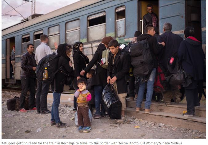
9 maps and charts that explain the global refugee crisis Updated by
 Concepts of Thinking: Spatial Significance, Patterns and Trends, Geographic Perspective
Inquiry: Why might so many people feel they have to leave their homeland? How might this trend be reversed?
Activity: Create a spatial journal of where people are leaving and where they are going to. Add to the map the reasons. Conduct an issue analysis of one region and develop a a possible solution. How might your solution apply to other regions? Communicate via story map.

These Countries with Business Links to Trump Aren’t Part of His Immigration Ban
 Concepts of Thinking: Patterns and Trends, Geographic Perspective, Spatial Significance
Inquiry: How might the Presidents business dealings impact the safety of this region?
Activity: Create a spatial journal of the area to document what has and is happening in these countries. Conduct an issue analysis of the conflict of interest in this region. Develop a possible solution and communicate solution via story map to the appropriate audience.

NASA Study Shows Global Sea Ice Diminishing, Despite Antarctic Gains
 Concepts of Thinking: Spatial Significance, Patterns and Trends
Inquiry: How might the difference in sea ice impact communities around the world? How might this loss of ice best be addressed?
Activity: Gather data regarding sea ice. Chart information and observe possible patters and trends. Create maps or access maps showing sea ice. How might spatial significance impact sea ice? What should be done to help maintain the sea ice? Create a story map to communicate results.

The war on baby girls winds down The Economist

Concepts of Thinking: Patterns and Trends, Spatial Significance,
Inquiry: How might this change impact communities? Why might it have taken this long for views to change?
Activity: Gather data on sex ratios around the world and create an annotated map. Observe any patterns. Evaluate and draw conclusion regard this trend. Communicate

Flooding More Than Doubled Across Europe in 35 Years By Arthur Neslen, The Guardian
 Concepts of Thinking: Spatial Significance, Patterns and Trends, Interrelationships
Inquiry: How might communities deal with this increase in flooding? What might the next 35 years look like?

What if the fighting in Aleppo was happening in Toronto?

Concepts of Thinking: Spatial Significance, Geographic Perspective, Interrelationships
Inquiry: What should be done to stop this Genocide? How might citizens end this Genocide because Governments aren't willing to do what needs to be done even after Yugoslavia, Rwanda, and the Sudan. What might this world look like if the powers that should don't?
Activity: Understand the issues by completing an issue analysis. Use the conversational and sensitive document to help deliver with delivery of the topic. Create a story map and share with appropriate audience to cause change.

Aleppo’s people are being slaughtered. Did we learn nothing from Srebrenica?

The world’s wet regions are getting wetter and the dry regions are getting drier

Concepts of Thinking: Patterns and Trends, Spatial Significance, Interrelationships
Inquiry: How might this pattern impact different communities around world.
Activity: Gather and organize the data and create a graph to interpret and evaluate the data. What prediction might be made? Create an annotated map to show where these evens are most likely to occur. Observe the map to determine the spatial significance of places impacted the most. Conduct an issue analysis to help evaluate for interrelationships. Communicate via story map.

CIA concludes Russia interfered to help Trump win election, say reports
Damien Gayle and agencies
 Concepts of Thinking: Geographic Perspective, Interrelationships
Inquiry: What might be to fallout of these findings?
Activity: Conduct an issue analysis on the situation. Create an annotated map if the stakeholders. Determine possible outcomes and communicate via story map.

Warming U.S. Could See Extreme Rains Increase Fivefold
By Andrea Thompson

Concepts of Thinking: Spatial Significance,
Patterns and Trends, Interrelationships
Inquiry: How might this impact Canadians?
Activity: Gather information on climate in Canada. Create an annotated map of the different regions in Canada. Conduct an issue analysis to come up with a plan to deal with any changes that might occur. Communicate via story map.
30 Years of Oil and Gas Pipeline Accidents, Mapped

Concepts of Thinking: Spatial Significance, Interrelationships, Patterns and Trends, Geographic Perspective
Inquiry: What might be the best location and method to transport fossil fuels? How might such accidents involving fossil fuel infrastructure be minimized? How might a better alternative to fossil fuels be distributed?
Activity: Conduct a Geographic inquiry to develop an alternative. Gather data on fossil fuel disasters and observe any patterns that may appear. Conduct an issue analysis to better understand the problem. Create an annotated map to show communities impacted by this type of infrastructure. Communicate results via story map.

Fake news tries to blame human-caused global warming on El Niño

Concepts of Thinking: Interrelationships, Geographic Perspective
Inquiry: How might people better protect themselves from fake news? How might fake news impact national policies? How might the spread of fake news impact others?
Activity: Gather information on fake news. Complete a Venn diagram to help determine the difference between fake, satire, and real news. Conduct an issue analysis to develop a possible solution. Communicate to an appropriate audience the concerns and solutions to the spread of fake news.

Standing Rock: US denies key permit for Dakota Access pipeline, in win for tribe
 Concepts of Thinking: Spatial Significance, Geographic Perspective, Interrelationships, Patterns and Trends
Inquiry: What might have been the reason why the government changed the location in the first place? How might the government proceed in determining an appropriate location for the pipeline?
Activity: Determine the characteristics of an appropriate site for the pipeline. Create an annotated map of the possibilities. Conduct an issue analysis to and determine a possible solution. Communicate via story map to an appropriate audience.

OPEC agrees first output cut since 2008; Saudis open to ‘big hit’, but details still unclear Ahmad Ghaddar, Alex Lawler and Rania El Gamal, Reuters
 Concepts of Thinking: Geographic Perspective, Interrelationships, Spatial Significance, Patterns and Trends
Inquiry: Who might these restrictions impact Canadians? Why might OPEC countries be willing to cut oil production?
Activity: Create an annotated map of OPEC countries and countries that import oil to. Observe for patterns and trends. Conduct an issue analysis to help evaluate the consequences of this reduction. Develop a plan to account for this project cuts and communicate via story map.

Inquiry: Who might these restrictions impact Canadians? Why might OPEC countries be willing to cut oil production?
Shrinking glaciers cause state-of-emergency drought in Bolivia
Jan Rocha for Climate News Network, part of the Guardian Environment Network
 Concepts of Thinking: Interrelationships, Spatial Significance, Geographic Perspective
Inquiry: How might this situation impact surrounding nations?
Activity: Create an annotated map of the glaciers in the region and the countries that depend on them. Conduct an issue analysis to help develop a solution to the problem. Communicate findings via story map to an appropriate audience.
Bolivians in La Paz fetch water from a tanker truck provided by officials of the Bolivian public water company, Epsas. Photograph: Martin Alipaz/EPA

An ugly homicide number we need to discuss
Scott Gilmore November 25, 2016
 Concepts of Thinking: Interrelationships, Geographic Perspective, Patterns and Trends, Spatial Significance
Inquiry: Why might Indigenous homicide rates be so high in the far north? What might be needed to reduce these rates?
Activity: Conduct an issue analysis to determine the views that might be contributing to the problem. Create an annotated map of collected data to illustrate the problem. Develop a solution and communicate via story map to an appropriate audience.

Shipping maps win at the Information Is Beautiful Awards
 Concepts of Thinking: Spatial Significance, Patterns and Trends,
Inquiry: How might this data be used by different stakeholders?
Activity: Gather information on the destination ports. Create graphs to indicate how the volume of transport. Create an annotated map for analysis and or developing more inquiry questions for exploration. Communiacte finding via story map.

Big oil v orcas: Canadians fight pipeline that threatens killer whales on the brink

Concepts of Thinking: Interrelationships, Spatial Significance, Geographic Perspective
Inquiry: What might be the best way to meet the need for oil and meet the need for conservation?
Activity: Use the concepts of thinking graphic organizers and conduct an issue analysis. Use this information to create a spatial journal to decide on how to move forward. Develop a story map to communicate to an appropriate audience.

Conservation Decisions Must Protect the Livelihoods of People Living in Africa
By: Ross Harvey
 Concepts of Thinking: Spatial Significance, Interrelationships, Geographic Perspective, Patterns and Trends
Inquiry: How might conservation interact with development?
Activity: Conduct an issue analysis of one of the concerns in the reading. Use the concepts of thinking graphic organizers to clarify the problem. Create a spatial journal of different concerns. Develop a resolution and then communicate via story map to an appropriate audience.

How other countries would vote in the American election
 Concepts of Thinking: Spatial Significance, Geographic Perspective, Interrelationships, Patterns and Trends
Inquiry: How might this world view impact how Trump leads?
Activity: Conduct an issue analysis and create a spatial journal of the countries views. Create a story map to communicate results to an appropriate audience

Photo of the Day National Geographic
 Concepts of Thinking: Spatial Significance, Interrelationships, Geographic Perspective, Patterns and Trends
Inquiry: Where might these photos have been taken. Why might these photos have been taken?
Activity: Examine the photos and develop inquiry questions that might be used for each of the photos. Try to answer the questions and communicate.
Every year, nearly 1.3M people die in traffic accidents.
 Concepts of Thinking: Patterns and Trends, Spatial Significance
Inquiry: How might car fatalities be stopped globally?
Activity: Gather data to create a spatial journal of car fatalities. What might account for any patterns and trends that can be observed? Conduct an issue analysis of the issue. Communicate via story map.

Every year, nearly 1.3M people die in traffic accidents.

Oil may hit ‘low-$40s’ if OPEC fails to deliver quota deal: Goldman Sachs Ben Sharples, Bloomberg News
 Concepts of Thinking: Interrelationships, Spatial Significance, Geographic Perspective, Patterns and Trends
Inquiry: How might the change in oil prices impact Canadians?
Activity: Gather data on world oil prices and the global economy. Create a spatial journal of key events. Make predictions as to what now might happen and communicate via a story map.

Inquiry: How might the change in oil prices impact Canadians?
Italy earthquake: 6.6-magnitude tremor rocks nation's center
 Concepts of Thinking: Spatial Significance, Patterns and Trends, Interrelationships
Inquiry: How could people prepare for such an event?
Activity: Create a spatial journal of past earth quakes in the region (patterns and trends). Conduct an issue analysis to develop possibilities to help the region. Communicate via story map.

Global Gender Pay Gap Won't Close For 170 Years: Report By The Associated Press
 Concepts of Thinking: Patterns and Trends, Spatial Significance, Geographic Perspective
Inquiry: What might be necessary to create a situation where women and men earn the salary for the same work?
Activity: Create a spatial journal of the countries and the percentage gap they hold. Observe for patterns and trends and develop a strategy that might help improve the situation for women so that they can actually earn the same. Communicate the strategy via story map.

The Migration of Anatomically Modern Humans
 Concepts of Thinking; Spatial Significance, Patterns and Trends
Inquiry:Why might people have migrated? How might people have traveled? Why did people choose their routes? How might these routes relate to current migration routes?
Activity: Gather data on current migration (An other source). Create a proportional width arrow map indicating routes and numbers. Conduct an issue analysis and develop predictions to help meet the needs of future migrants. Communicate via story map.

Delhi airport first carbon neutral airport in Asia-Pacific Press Trust of India | New Delhi

Concepts of Thinking: Geographic Perspective, Spatial Significance, Patterns and Trends, Interrelationships
Inquiry: How might other airports react to this event?
Activity: Create a spatial journal of the airports in the region. Investigate how airports might be concerned with the environment. Conduct an issue analysis to determine how more airports could be carbon neutral. Communicate suggestions via story map.
 Concepts of Thinking: Interrelationships, Geographic Perspective, Patterns ad Trends
Inquiry: How might women be able to impact past farming practice?
Activity: Create a spatial journal of places around the world that have incorporated the women's perspective and compare that with areas that haven't. Can any patterns be observed? What may account for these patterns? What might be needed to get more places to incorporate women's perspective? What other social areas could be positively impacted by listening and incorporating women's perspective? Communicate finding via story map.


Second Harvest Turns Food Waste Into 22,000 Free Meals A Day
 Concepts of Thinking: Geographic Perspective, Patterns and Trends
Inquiry: Why might there be so much waste of food? How can people reduce their waste? What might be required to help reduce the number of people going hungry?
Activity: Conduct some research on hunger in Canada and the world. Create a spatial journal of food waste and hunger are there any patterns and trends that can be observed. Conduct an issue analysis to determine possible solutions and communicate via story map.

Expect a warmer-than-normal fall, says Environment Canada
 Concepts of Thinking: Spatial Significance, Patterns and Trends, Interrelationship, Geographic Perspective
Inquiry: What might the warmer fall impact look like? How could this weather impact different populations?
Activity: Research weather patterns in Canada. Create a spatial journal of weather from past to present. How might meteorologist be able to predict the weather How does this current weather prediction fit in? Make predictions of impacts based on the climate predictions. Communicate predictions and possible actions required via story map to an appropriate audience.

ENDANGERED SPECIES: WHY SHOULD I CARE? ·

Brazil ratification pushes Paris climate deal one step closer. Jeff Tollefson
 Concepts of Thinking: Geographic Perspective, Interrelationship, Spatial Significance, Patterns and Trends
Inquiry: How might Brazil's ratification impact Paris climate deal?
Activity: Conduct an issue analysis of the Paris accord. Create a spatial journal of countries involved. Create a story map to communicate to an appropriate audience the impacts of Brazil's ratification.

Canadian Economy Needs 10, 15 Years To Reinvent Itself, RBC CEO Says
 Concepts of Thinking: Patterns and Trends, Geographic Perspective, Spatial Significance
Inquiry: Why might the Canadian Economy need to reinvent itself?
Activity: Conduct an issue analysis to help develop an increased understanding of the issue. Create a spatial journal of the different regions and what possible changes might be needed. Come up with strategies to facilitate reinvention ans communicate to an appropriate audience via story map.

GIANT PANDAS ARE NO LONGER ENDANGERED 09/07/2016 ·
 Concepts of Thinking: Spatial Significance, Geographic Perspective, Patterns and Trends, Interrelationships
Inquiry: What might be required to ensure the continued success of the Panda? How might other endanger species have the same type of success?
Activity: Create a spatial journal of the factors and events that have contributed to the success of the Panda. Indicate how the range of the Panda my be impacted. Choose another endangered species and create a spatial journal of it's could change if the species could experience the same success as the Panda. Conduct an issue analysis for the creation of a story map to make suggestions on how to implement change for an endangered species.

Study suggests size of Zika epidemic may be underestimated
image source: unknown

Concepts of Thinking: Geographic Perspective, Patterns and Trends, Spatial Significance
Inquiry: What might be needed to better understand the Zika virus? How might location data contribut to more accurate number of cases?
Activity: Create a spatial journal of positive virus contacts. Observe for any patterns and trends. Conduct an issue analysis to determine a course of action to help reduce the spread of the virus. Communicate results to an appropriate audience via story map.


Study documents a lost century for forest elephants Science MAG admin August 31, 2016
 Concepts of Thinking: Geographic Perspective, Spatial Significance, Patterns and Trends
Inquiry: How might the elephants be best protected from poaching?
Activity: Create a spatial journal indicating the range of the forest elephants and where the poaching is taking place. Evaluate any patterns that may appear. Conduct an issue analysis to help develop strategies to stop the poaching. Communicate results via a story map.

Dead Sea drying: A new low-point for Earth By Kevin Connolly, BBC Middle East correspondent, 17 June 2016
 Concepts of Thinking: Spatial Significance, Patterns and Trends, Interrelationships, Geographic Perspective
Inquiry: How might human activity contribute to the state of the Dead Sea? What might be the best solution to dealing with the decrease water level of the Dead Sea?
Activity: Create a spatial journal of the area taking not consideration drainage basins, human settlement, human activity, and climate patterns. Conduct an issue analysis to evaluate perspectives. Determine a plausible solution and communicate via story map to an appropriate audience.

Global forced displacement hits record high By: Adrian Edwards
 Concepts of Thinking: Interrelationships, Spatial Significance, Patterns and Trends
Inquiry: Why are the refugees being forced to move from their homes? Why might the go to the countries/regions they go to?
Activity: Gather data on refugees and create a spatial journal and evaluate for patterns and trends. Create a story map to communicate what might be done to help reduce the number of refugees.

Canadian, U.S., mayors oppose Great Lakes water diversion request CTV News
 Concepts of Thinking: Spatial Significance, Geographic Perspective
Inquiry: How might this diversion impact the Great Lakes ecosystem?
Activity: Conduct an issue analysis for the proposal. Create a spatial journal of the Great Lakes St. Lawrence Water Way. Create a story map to communicate whether or not the proposal should be excepted and communicate to an appropriate audience.

Did the Liberals have to wait to call ISIS genocidal? MACLEANS magazine
 Concepts of Thinking: Interrelationship, Patterns and Trends,
Inquiry: Now that the UN and Canada have called the actions of ISIS as genocidal how long before meaningful action is taken by all UN to stop this ISIS?
Activity: Create a spatial journal of ISIS territory and events to evaluate the spatial significance. Conduct an issue analysis and develop a plan that can deal with the situation. Communicate a possible solution to the situation via story map to an appropriate audience.
 Concepts of Thinking: Interrelationship, Patterns and Trends,
African youth to African leaders: “You must do more to end conflicts in Africa”
 Concepts of Thinking: Interrelationships, Spatial Significance,
Inquiry: How might Humanitarian crisis in Africa be addressed?
Activity: Create a Spatial Journal of the data from the survey and then create a Story Map to communicate a message to an appropriate audience.

About Latin America and the Caribbean
 Source: UNDP
Concepts of Thinking: Spatial Significance,
Patterns and Trends, Geographic Perspective
Source: UNDP
Concepts of Thinking: Spatial Significance,
Patterns and Trends, Geographic Perspective
Inquiry: How might focusing on Health, Education, and the Environment help improve peoples lives? Why might other Governments not employ the same strategy to help their people?
Activity: Conduct an issue analysis and create a spatial journal of the stakeholders. Investigate other countries and develop a plan to help other countries move forward. Communicate strategies to an appropriate audience via story map.
Statement on Terrorist Attack in Orlando, Florida
 Concepts of Thinking: Interrelationship, Patterns and Trends, Spatial Significance
Inquiry: How might spatial significance have contributed to this behaviour? How may these patterns violence have changed over time? How might people be supported to move forward and not develop such violent tendencies?
Activity: Create a spatial journal of countries that are fighting this type of hate crime. Conduct an issue analysis of the problem. Create story map to communicate a possible solution to this problem.
 Concepts of Thinking: Interrelationship, Patterns and Trends, Spatial Significance
This mind-blowing infographic shows the incredible depth of the earth's oceans Pamela Engel
 Concepts of Thinking: Spatial Significance, Interrelationships, Geographic Perspective,
Inquiry: How might we reach the bottom of the oceans? What might the impacts be of reaching the bottom?
 Concepts of Thinking: Interrelationships, Patterns and Trends, Geographic Perspective, Spatial Significance
Inquiry: When might oil companies be able to stop these leaks from happening? What might be the cumulative impact of these types of oil spills, under the 100,000 gallon threshold of a major spill? How accurately do these companies report such leaks?
Activity: Conduct an issue analysis and then create a spatial journal of the Gulf Mexico relating to this problem. Add data such as oil platforms, oil spills, natural habitats etc. Develop a plan that will be able to help increase the sustainability of this industry. Communicate via a story map and communicate to an appropriate audience.

 Concepts of Thinking: Interrelationships, Patterns and Trends, Geographic Perspective, Spatial Significance
Canada Calls Out Russia For Lack Of Warning About Incoming Rocket

Concepts of Thinking: Spatial Significance, Interrelationships, Geographic Perspective
Inquiry: How can the Russian Government be accurate regarding the location of the debris re-entry? How might the Russian government respond to Canada's "Call Out" of Russia?
Activity: Create a spatial journal of the area to be impacted. Add to it human and animal information of the area. Conduct an issue analysis to develop a solution. Communicate the solution to an appropriate audience via story map.

India’s Severe Drought Causing Havoc
 Concepts of Thinking: Spatial Significance, Patterns and Trends, Interrelationships, Geographic Perspective
Inquiry: How could these conditions have been predicted and/or prevented? How might India's drought impact other parts of the world?
Activity: Conduct an issue analysis of the problem. Create a spatial journal of the stakeholders, physical and climatic factors. Evaluate graphs and charts of climate. Develop a potential solution to the problem and communicate via story map to the appropriate audience.
 Concepts of Thinking: Spatial Significance, Patterns and Trends, Interrelationships, Geographic Perspective
Boil water advisory in effect for Gatineau CBC News
 Concepts of Thinking: Interrelationships, Spatial Significance, Geographic Perspectives,
Inquiry: How might the reaction to the Hull boil water advisory be different from the
Neskantaga First Nation of nearly 20 years?
Activity: Create a spatial journal of boil water advisories in Canada. Add community and infrastructure data. Conduct an issue analysis to gain regarding access to clean water. Communicate a plan to make clean water accessible to all Canadians via story map.

Neskantaga First Nation of nearly 20 years?
Returning Fort McMurray residents face long road to recovery By Amy Husser, CBC News
 Concepts of Thinking: Interrelationships, Patterns and Trends, Geographic Perspective
Inquiry: How might be the focus of Fort McMurray's redevelopment impact the future growth of the city?
Activity: Create a spatial journal of the resources currently supporting Fort McMurray. Add possible alternative/new resource opportunities, natural features, and human activity data. Evaluate the map to develop a plan for redevelopment that could better protect the city from being a boom bust, one resource, based city. Communicate the plan to the appropriate audience via story map.

Romeo Dallaire: Rwandan Genocide Is Being Repeated Right Now In Syria
 By Mike Blanchfield, The Canadian Press
Concepts of Thinking: Patterns and Trends, Spatial Significance, Geographic Perspective, Interrealtionships
By Mike Blanchfield, The Canadian Press
Concepts of Thinking: Patterns and Trends, Spatial Significance, Geographic Perspective, Interrealtionships
Inquiry: We try to teach our kids to stand up to Bullies, yet our Governments do not. How might it be possible for World Leaders to knowingly sit back at let the newest Genocide continue? What might be the best way to deal with this current Genocide? What might be necessary for World Leaders to classify the Syrian Conflict as a Genocide
Activity: Conduct an issue analysis. Gather information on the stakeholders including the UN. Try to develop a plan that can address the problem and bring an end to the Syrian conflict. View Not My Fault . How might this relate to the problem? Communicate solution via story map to the UN and ask for a reply.

Refugee crisis: 'More than 700' feared dead in Mediterranean shipwrecks
 Concept of Thinking: Spatial Significance, Interrelationships, Patterns and Trends
Inquiry: At what point might the United Nations and World leaders develop and implement a realistic strategy to deal with the refugee crisis either by addressing the cause, conflict in the Middle East or the consequences Human Traffickers and Immigration destination? Why is the world just standing by and watching?
Activity: Create a flow chart to gather data on the issue. Conduct an issue analysis to gain information regarding the stakeholders. Create a spatial journal of the stakeholder and the crisis locations. Evaluate for patterns and trends and develop a strategy to address the problem, the cause and /or the consequences. Communicate via story map recommendations for the UN and other World Leaders to bring an end to this catastrophe.

Self-sustaining eco-communities aimed at regenerating the world one village at a time Stu Robarts May 26, 2016

Concepts of Thinking: Spatial Significance, Interrelationships,
Inquiry: How will the appropriate locations be selected to establish the eco-community? How could these communities impact local environments?
Activity: Establish the criteria for location selection and map out the ideal locations for the eco-communities and create a map. Conduct an issue analysis to evaluate the likelihood of these communities being established. Communicate recommendations to an appropriate audience via story map.
 Concepts of Thinking: Geographic Perspective, Spatial Significance, Interrelationships
Inquiry: How might Australia's economic concerns be addressed at the same time as supporting environmental concerns?
Activity: Conduct an issue analysis keeping in mind the Geographic Perspective. Create a map of stakeholder and develop a potential solution. Present your conclusion to UNESCO via story map.
 Concepts of Thinking: Geographic Perspective, Spatial Significance, Interrelationships
Climate Change in Images
 Concept of Thinking: Spatial Significance, Interrelationships, Patterns and Trends, Geographic perspective
Inquiry: How might the world accommodate Environmental Refugees? What might be necessary to move all countries involved in the Paris accord to actually meet the Goals?
Activity: Conduct an issue analysis of the countries involved. Create a spatial journal of the stakeholders. Analyse any patterns or trends, evaluate the spatial significance and develop a implementable solution that can be communicated via story maps.
 Concepts of Thinking: Interrelationships, Patterns and Trends, Spatial Significance
Inquiry: Why might the "weeds of the sea" be on the increase? How might this increase impact local environments/human activities?
Activity: Create a spatial journal of the squids and octopuses. Add to it human activity in these regions. Conduct an issue analysis to help determine impacts of this increase in squid and octopus population. How might different groups deal with this increase? Communicate results via story map. Other resources


Not all wood pellets are carbon-neutral, says environmental advocate By Mitch Wiles, CBC News Posted: May 25, 2016 6:00 AM CT
 Concepts of Thinking: Geographic Perspective, Interrelationships,
Inquiry: Why are wood pellets being used instead of wood for burning? How can a carbon wood pellet be made carbon -neutral? Why might whole trees be used to create wood pellets?
Activity: Conduct an issue analysis and map out the stakeholders. How might spatial significance impact the type of wood pellet? Moving forward how should industries react to the findings that not all wood pellets are carbon-neutral? Communicate results via story map.
 Concepts of Thinking: Spatial Significance,
Patterns and Trends, Geographic Perspective, interrelationship
Concepts of Thinking: Spatial Significance,
Patterns and Trends, Geographic Perspective, interrelationship
Inquiry: Where might the best location be for these innovations? How might they contribute to the Canadian economy? How might these innovations impact the local environment?
Activity: Determine the criteria of each of the innovations to locate the possible places for these innovations. Create a spatial journal indicating the selected locations. Why patterns and trends develop? Compare the different types of innovations to determine the most likely to have the largest impact to Canada. Create a story map to communicate results.


New study finds major earthquake threat from the Riasi fault in the Himalayas
 Concepts of Thinking: Geographic Perspective, Spatial Significance, Interrelationship
Inquiry: How might a major earthquake impact the Geographic Perspective of the area? How might people of the area prepare for the inevitable?
Activity: Create a spatial journal of earthquakes looking for patterns and trends to establish where vulnerable areas might be. Add population data to aid in the analysis. Create a story map to communicate results.

WORLD’S SMALLEST PORPOISE IS ON THE VERGE OF EXTINCTION
 Concepts of Thinking: Interrelationships, Patterns and Trends, Spatial Significance
Inquiry: How might gill fishing be stopped? How can the fishing of endangered species be allowed? How should governments and industries deal with this issue? What might some of the environmental issue be if this species becomes extinct?
Activity: Create a spatial journal of the issue by adding data of species range, human activity (fishing) and conduct an issues analysis to help determine a potential, doable, solution to the problem. Create a story map to communicate to an appropriate audience.
Climate change puts 1.3bn people and $158tn at risk, says World Bank
Larry Elliott Economics editor
 Concepts of Thinking: Geographic Perspective, Spatial Significance, Interrelationships
Inquiry: Even the most Capitalistic corporations will be worried about that much loss to their work force and their bottom line so why do some corporations still pretend Climate Change isn't a problem?
Activity: Create a spatial journal indicating where the most at risk areas are to Climate Change. Add to it population data for further analysis. How does Spatial Significance fit into problem? Can any Patterns and Trends be observed? Conduct an issue analysis and communicate strategies to deal with the issue via story map.
PERCEPTIONS
INDEX 2015 


 Concepts of Thinking: Patterns and Trends, Spatial Significance, Interrelationships, Geographic Perspective
Inquiry: How might Global Corruption impact people around the world? How can the people hurt the most from Global Corruption be helped? How might Global Corruption be dealt with to reduce its impact? Why might this Transparency International map not show the same patterns as the Panama Papers map? Why might two maps showing corruption in the world be different?
Activity: Create a thematic map of the high ranking countries and low ranking countries. Are any patterns evident? Why might this pattern appear? Conduct an issue analysis to develop a solution to the situation. How might the solution be introduced to the world? Create a story map to communicate the solution to the appropriate audience.

Air pollution levels rising in many of the world’s poorest cities World Health Organization
 Concepts of Thinking: Spatial Significance, Interrelationships, Patterns and Trends
Inquiry: What might be contributing to this trend? How will this trend impact the rest of the world?
Activity: Collect data on cities which are contributing the most air pollutants and create pie charts showing pollution per capita data spatial journal. Add to it population data and climate conditions to make predictions on future global impacts. Conduct an issue analysis to determine a potential solution to the pollution situation and communicate via story map.
CAPTIVE MARKET: UNDERSTANDING NUNAVUT’S COMPLEX AIRLINE INDUSTRY
 Concepts of Thinking: Spatial Significance, Patterns and Trends, Geographic Perspective
Inquiry: How might increased travel to the North and Iqaluit’s new international airport impact local ecosystems?
Activity: Create a spatial journal of the region containing human and environmental data. Conduct an issue analysis and make a judgement on what would be best for the region. Communicate results to an appropriate audience via story map.

CAPTIVE MARKET: UNDERSTANDING NUNAVUT’S COMPLEX AIRLINE INDUSTRY

Lancaster Sound
An integral part of the Last Ice Area and an Arctic home for Inuit and wildlife
 Concepts of Thinking: Spatial Significance, Interrelationships, Patterns and Trends
Inquiry: How might Climate Change impact this region?

Syria accused of airstrike on refugee camp as Assad pushes for 'final victory'
 Concepts of Thinking: Patterns and Trends, Interrelationships, Geographic Perspective
Inquiry: What might be the tipping point at which UN members vow to resolve the situation. Why have we not learned from Rwanda, etc?
Activity: Conduct an issue analysis and map the participants. Add to the map demographic data . Create a story map with outlining a possible solution and communicate to an appropriate audience.

Zimbabwe’s Wild Animals For Sale: National Parks Forced To Sell Wildlife Amid Drought BY MORGAN WINSOR, INTERNATIONAL BUSINESS TIMES
 CONCEPTS OF THINKING: SPATIAL SIGNIFICANCE, GEOGRAPHIC PERSPECTIVE, PATTERNS AND TRENDS
INQUIRY: WHAT MIGHT BE A BETTER ALTERNATIVE TO SELLING THE ANIMALS? HOW MIGHT SELLING OF THE ANIMALS IMPACT THEIR WELL BEING? WHEN MIGHT THE WEATHER CONDITION CHANGE TO SUPPORT THE ANIMALS?
ACTIVITY: CONDUCT AN ISSUE ANALYSIS TO HELP DETERMINE THE IMPACT OF SELLING THE ANIMALS AND MAP. ADD TO THE MAP THE LOCATION OF THE ANIMALS TO BE SOLD AS WELL AS WEATHER PATTERNS AND TRENDS TO HELP MAKE A PREDICTION AS TO WHEN CONDITION MIGHT GET BETTER.

Peak Oil Could Hit In Just 14 Years, But It Might Not Be What You Think
The Huffington Post Canada | By Jesse Ferreras
 Concepts of Thinking: Patterns and Trends, Geographic Perspective, interrelationships, Spatial Significance
Inquiry: How might peak oil be calculated? What might the impacts be of reaching Peak Oil?
Activity: Conduct an issue analysis. Analyze maps, graphs and charts to make predictions on the effects of reaching Peak Oil. Create a story map to communicate results to an appropriate audience.

In Photos: The Largest Burning of Ivory in History By Frederick Paxton and Ben Bryant
 Concepts of Thinking: Patterns and Trends, Interrelationship, Spatial Significance, Geographic Perspective
Inquiry: If ivory is so expensive why might people be burning so much of it? What might be the impact of burning this ivory be?
Activity: Create a proportional width arrow map of where the ivory is coming from and where it is going. Conduct an issue analysis to help understand the stakeholders. Make prediction as to what might happen and create recommendations as to what should be happening that can be used to communicate to a particular audience.

El Niño and the stratospheric polar vortex
Author: Amy Butler
 Concepts of Thinking: Spatial Significance, Patterns and Trends, Interrelationship
Inquiry: How might the vortex impact El Nino? How might human activities contribute to these environmental events
Activity: Create a map of the areas affected by each of these environmental events, human activities/development in the area. Use graphs and charts to make predictions of future events and map out results that can then be communicated to the appropriate audience via story map.

California plans to unleash fly to crush ivy invasion By

 Concepts of Thinking: Spatial Significance, Interrelationships, Patterns and Trends
Inquiry: How might be a plausible
Activity: Conduct an issue analysis and map out the data as well as the extent of the bleaching along the Reef. Add to the map human data i.e. distribution, industry etc. Create a story map to communicate your results
 Concepts of Thinking: Spatial Significance, Interrelationships, Patterns and Trends
Canadian waters getting safer, but research gaps limit full understanding of shipping risks
 Concepts of Thinking: Spatial Significance, Geographic Perspective, Patterns and Trends, Interrelationship
Inquiry: What might be needed to better understand the shipping risk?
Activity: Conduct an issue analysis. Create a map of the stakeholders to help develop a solution. Create a story map showing a possible solutions to reduce shipping risks in Canadian waters.

Do fracking activities cause earthquakes? Seismologists and the state of Oklahoma say yes By Terry Reith and Briar Stewart, CBC News
 Concepts of Thinking: Spatial Significance, Patterns and Trends, Geographic Perspective
Inquiry: How could Fracking contribute to earthquakes
Activity: Create a map of where fracking is taking place. Add to it data about where earthquake epicentres are located as well as population information. Observe any patterns that may have appeared. Gather other information on fracking. Decide weather fracking can contribute to earthquakes or not. Create a story map to communicate to an appropriate audience a solution to the situation.

Arctic Cruises Are Extinction Tourism By Another Name Capt. Trevor Greene
 Concepts of Thinking: Geographic Perspective, Spatial Significance, Patterns and Trends, Interrelationship
Inquiry: How might tourist enjoy the Arctic without destroying it? What have been solutions in other similar situations? Could these solutions work for the the Arctic?
Activity: Map out the areas of greatest impact. Conduct an issue analysis and add to map the stakeholders. Determine a best fit solution and communicate to an appropriate audience via story map.
 Concepts of Thinking: Geographic Perspective, Spatial Significance, Patterns and Trends, Interrelationship
Brazil swine flu: H1N1 vaccinations to begin as virus kills 230 BBC
 Concepts of Thinking: Interrelationship, Patterns and Trends, Spatial Significance,
Inquiry: Where did this virus originate from?How might this virus be prevented, stopped from spreading? Where might this virus move to?
Activity: Create a map of the areas that are affected, past and present. Determine the spatial significance that contribute to the movement of the virus. Make predictions as to where the virus could move to. How might geographic perspective contribute to how the virus could be dealt with. Communicate result to an appropriate audience via story map.

Brazil Amazon dam project suspended over concerns for indigenous people
Bruce Douglas in Rio de Janeiro
 Concepts of Thinking: Geographic Perspective, Spatial Significance, Patterns and Trends, Interrelationships
Inquiry: How might the Brasil now meet their energy needs? How might other countries show they listen to the concerns of their indigenous people?
Activity: Create an energy map of Brasil, generation and distribution. Conduct an issue analysis. Determine an alternative energy source and communicate to an appropriate audience.

Hunger Map 2015 World Food Programme
 Concepts of Thinking: Spatial Significance, Patterns and Trends, Geographic Perspective
Inquiry: In a world that is able to produce a surplus of food why are people still allowed to go hungry? How might a countries hunger rating change if only looking at domestic data (Canada as an example)?
Activity: Determine the stakeholder and conduct an issue analysis. Create flow map of the distribution of food. Add to the the flow of resource and aid countries around the world are involved in. Other data. Do any patterns appear? What might be some conclusions that can be made about food scarcity and Geographic Perspective and or Spatial significance? Communicate results to an appropriate audience via story map.


Nice Blog. Thank you sharing this information it is very useful to all.
ReplyDeletewater treatment plant in chennai
water treatment companies in Chennai
sewage treatment plant in chennai
sewage treatment plant in bangalore
waste water treatment plant
effluent treatment plant
sewage treatment plant
best water treatment companies