Diesel cars' emissions far higher on road than in lab, tests show Peter Walker and Graham Ruddick
 Concepts of Thinking: Spatial Significance, Patterns and Trends, Geographic Perspective
Inquiry: What might some of the consequences be to these increase levels? Where might these impacts be felt the most?
Activity: Create a map of the regions of the world that have diesel cars on the road. Add to the map air quality data and human patterns. Make some predictions of environmental impacts. Communicate to an appropriate audience via story map.
Turkish Air Strikes Hit PKK Camps In Northern Iraq After Ankara Bombing 
 Concepts of Thinking: Geographic Perspective, Spatial Significance
Inquiry: How might the bombing impact the ongoing Syrian conflict?
Activity: Create a map (spatial journal) of the area incorporating the stakeholders and events related to the conflict and complete an issue analysis to help develop an understanding of the conflict. Communicate a potential solution to the appropriate stakeholder via story map.

Report on Syria conflict finds 11.5% of population killed or injured
Ian Black Middle East editor
 Concepts of thinking: Geographic Perspective, Patterns and Trends, Spatial Significane
Inquiry: At what point might it be possible for UN to label this conflict a Genocide?
Activity: Use an issue analysis chart to help develop a solution to this conflict. Map out the Stakeholder, manage the data in a spatial journal to create a visual of the spatial significance of the conflict. Communicate your developed solution in a story map to communicate to the appropriate audience...UN?
Exploring Humanitarian Law (EHL)
 Concepts of Thinking: Geographic Perspective, Spatial Significance, Interrelationships, Patterns and Trends
Activity: Use this resource to meet Geographic curriculum expectations for wide range of courses.

Campaign Notebook: Where the local races matter
The Globe and Mail
Published
Last updated
 Concepts of Thinking: Geographic Perspective, Spatial Significance,
Lesson idea: Follow WHERE THE LEADERS ARE going and create a spatial journal. Input the information into the pop up.
The Globe and Mail
Published
Last updated
Photo Gallery: New 7 Wonders vs. Ancient 7 Wonders

Concepts of Thinking: Spatial Significance, Geographic Perspective, Patterns and Trends
Lesson Idea: Have students create a spacial journal of all the Wonders of the World and make some observations. Ask the questions; What Is Where? Why There? and Why Care?
|
Killer whale with dolphin pod off Nova Scotia a rare sight
 Concepts of Thinking: Interrelationships, Geographic Perspective,
Lesson idea:
Investigate What Is Where? Nova Scotia
Why There?
Why Care?
Why might this be of interest?

EU governments push through divisive deal to share 120,000 refugees
Czech Republic, Slovakia, Hungary and Romania vote against decision to impose quotas,
as lack of consensus threatens to feed resentment
Concepts of Thinking:
Geographic Perspective, Patterns and Trends, Spatial Significance
Create a spatial journal to determine:
What Is Where? and discuss Why There?
BBC News Middle EastSyria profile - Timeline15 September 2015Middle East
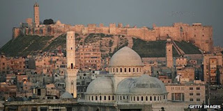 Concepts of Thinking: Patterns and Trends, Geographic Perspective, Spatial SignificanceCreate a spatial journal/time line of events to help analyse contributing factors (Concepts of Thinking) of this issue to help determine a possible solution. Aleppo, along with Damascus, is one of the oldest continuously inhabited cities
as lack of consensus threatens to feed resentment
Geographic Perspective, Patterns and Trends, Spatial Significance
What Is Where? and discuss Why There?

Chile's quick response to quake kept death toll down
Speedy, orderly evacuation of more than one million people after Wednesday's 8.3-magnitude earthquake shows how effective early warning systems and disaster-preparedness plans can be.

Concepts of Thinking: Patterns and Trends, Interrelationships, Spatial Significance
A man sits by fishing boats that were run aground by the sea while berthed in the port of Coquimbo, about 445 kilometres north of Santiago, Chile, during the earthquake Wednesday night.
By: Marina Jimenez Toronto Star, Published on Thu Sep 17 2015

Mississauga mayor leads charge to raise $5M for Syrian refugees

Concepts of Thinking:
Geographic Perspective
Geography definition: What is Where? Why Care?
Mississauga Mayor Bonnie Crombie, seen here at the Hershey Centre as Malcolm Turner, President of the NBA Development League, looks on, in June wants to see the city do more for refugees.

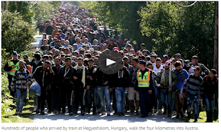
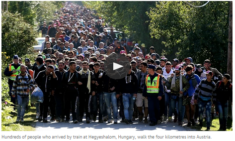
Refugee crisis escalates as migrants break through Hungarian border
Clashes with police follow moves by desperate refugees to break through a border gate, as others make their way to Croatia
Concepts of Thinking: Geographic Perspective, Patterns and Trends, Spatial Significance, Interrelationships

Greek referendum no vote signals huge challenge to eurozone leaders
Concepts of Thinking: Geographic Perspective, Spatial Significance
Poles of Inaccessibility -

Barrow, Alaska

Concepts of thinking: Spatial significance, geographic perspective, interrelationships
Clashes with police follow moves by desperate refugees to break through a border gate, as others make their way to Croatia
Concepts of Thinking: Geographic Perspective, Patterns and Trends, Spatial Significance, Interrelationships

Greek referendum no vote signals huge challenge to eurozone leaders
Victory by Syriza party of 60% to 40% in polarising referendum presents nightmare for eurozone elites, particularly German chancellor Angela Merkel

No vote supporters hold a banner during celebrations in Athens as results begin to indicate a clear victory against eurozone austerity measures Photograph: Alexandros Michailidis/Demotix/Corbis
Poles of Inaccessibility -
the Remotest Places on Earth

Barrow, Alaska

Uganda: the human story behind gorilla tourism
http://tinyurl.com/batwa-and-tourism

Concepts of thinking: Geographic perspective, interrelationships, spatial significance, patterns and trends
Why might this situation have been allowed to happen to the Batwa?
An Australian Company Says Its New Extraction Process Could Bring Unlimited Lithium Supplies

Concepts of thinking: Geographic perspective, interrelationships, spatial significance, patterns and trends
Why might this situation have been allowed to happen to the Batwa?
An Australian Company Says Its New Extraction Process Could Bring Unlimited Lithium Supplies
“Micas could eclipse all the other resources currently known.”
http://tinyurl.com/New-Extraction
 Concepts of Thinking: Geographic Perspective, Spatial Significance,
Jason Deign , June 1, 2015
Chinese cruise ship sinks in Yangtze River with more than 400 missing – live updates
- 15 people bought to safety including 3 trapped in hull
- Captain and chief engineer detained by police
- Survivor: ship tilted after heavy rain seeped into cabins
- 458 were on board, most tourists aged 50 to 80
- Read the latest summary
Concepts of Thinking: Spatial Significance, Interrelationships,

Chinese rescuers stand on the upturned bottom of the capsized cruise ship in the Yangtze River in Jianli county, Photograph: Imaginechina/REX Shu
Human Development Indicators UNHDR
This web site is a great resource for comparing countries and their HDR values.
Concepts of Thinking: Spatial Significance, Pattern and Trends, Geographic Perspective
This two web page were posted earlier but I thought it would be worth posting again.
Gapminder and Worldmapper are websites that are inter active graphs, maps, and charts. Supporting lessons for Gapminder are also available.
Concepts of Thinking: Patterns and Trends, Geographic Perspective

http://www.worldmapper.org

A series of pictures showing some effects of population increase and the stress on the environment that comes with it.
http://tinyurl.com/effects-of-population-increase

NASA: Global Climate Change, Vital Signs of a Plant
Great slides of Then and Now dealing with Climate Change.
Concepts of Geographic Perspective: Spatial Significance, Patterns and Trends, Interrelationships
Concepts of Thinking: Geographic Perspective, Spatial Significance,
Jason Deign , June 1, 2015
- 15 people bought to safety including 3 trapped in hull
- Captain and chief engineer detained by police
- Survivor: ship tilted after heavy rain seeped into cabins
- 458 were on board, most tourists aged 50 to 80
- Read the latest summary
Concepts of Thinking: Spatial Significance, Interrelationships,

Chinese rescuers stand on the upturned bottom of the capsized cruise ship in the Yangtze River in Jianli county, Photograph: Imaginechina/REX Shu
Human Development Indicators UNHDR
This web site is a great resource for comparing countries and their HDR values.
Concepts of Thinking: Spatial Significance, Pattern and Trends, Geographic Perspective

This two web page were posted earlier but I thought it would be worth posting again.
Gapminder and Worldmapper are websites that are inter active graphs, maps, and charts. Supporting lessons for Gapminder are also available.
Concepts of Thinking: Patterns and Trends, Geographic Perspective
http://www.worldmapper.org
A series of pictures showing some effects of population increase and the stress on the environment that comes with it.
Concepts of Thinking: Spatial Significance, Interrelationships, Geographic Perspective
NASA: Global Climate Change, Vital Signs of a Plant
Wind Power Around the World
Here is a great graphic showing the amount of energy generated from wind around the world.
Concepts of Geographic Thinking: Spatial Significance, Patterns and Trends
Suggested use: Have students create a spatial journal using ArcGIS on line.
Roam the World in (Almost) Real Time
Concepts of Thinking: Geographic Perspective, Spatial Significance
Here is a great graphic showing the amount of energy generated from wind around the world.
Concepts of Geographic Thinking: Spatial Significance, Patterns and Trends
Suggested use: Have students create a spatial journal using ArcGIS on line.
Roam the World in (Almost) Real Time
Shell oil drilling in Arctic set to get US government permission
Controversial decision expected from US interior secretary likely to spark protests from campaigners against Anglo-Dutch exploration in seas off Alaska
 Geographic Concepts of Thinking: Spatial Significance, Geographic Perspective
UN calls for action as global water crisis looms
Concepts of thinking: Geographic Perspective, Pattern
AQUEDUCT World Resource Institute
A great resource for World Issues
Concepts of Thinking: Spatial Significance, Patterns and Trends, Interrelationships
Home » Maps & Cartography » 6 Amazing Global
Agriculture Maps – Farming Visualized
A great resource for
World Issues
Geographic Concepts of Thinking: Spatial Significance, Geographic Perspective
UN calls for action as global water crisis looms
The UN has warned that the world will soon face a crisis of huge dimensions if water management does not improve. Population growth and climate change are among the factors fueling the problem.
Concepts of thinking: Geographic Perspective, Pattern
AQUEDUCT World Resource Institute
A great resource for World Issues
Concepts of Thinking: Spatial Significance, Patterns and Trends, Interrelationships
Home » Maps & Cartography » 6 Amazing Global Agriculture Maps – Farming Visualized
The Shocking Truth About What It Would Cost Walmart If It Paid a Living Wage.
In two minutes, economist Robert Reich completely destroys every possible excuse for Walmart’s low wages…
Click on the link: http://tinyurl.com/qaksn92
Concepts of Thinking: Geographic Perspective, Interrelationships, Patterns and Trends,
British gold mining firm agrees settlement over deaths of Tanzanian villagers
Acacia Mining – formerly African Barrick Gold – has agreed an undisclosed payout over claims that hired police and security guards killed and injured villagers at its North Mara mine in Tanzania

Concepts of Thining: Geographic Perspective, Spatial Significance, Interrelationships, Petterns and Trends
Acacia Mining’s (formerly African Barrick Gold) North Mara mine in Tanzania where villagers were killed and injured at an incident involving police and security guards in 2008. Photograph: Trevor Snapp/Getty Images
Hundreds of migrants feared dead in Mediterranean this week Concepts of Thinking: Geographic Perspective, Spatial Significance, Interrealtionships
The Haiti earthquake five
years on - then and now
- Click each image to show the
same location, five years on
Concepts
Of Geographic Thinking: Patterns and Trends

Acacia Mining – formerly African Barrick Gold – has agreed an undisclosed payout over claims that hired police and security guards killed and injured villagers at its North Mara mine in Tanzania
Acacia Mining’s (formerly African Barrick Gold) North Mara mine in Tanzania where villagers were killed and injured at an incident involving police and security guards in 2008. Photograph: Trevor Snapp/Getty Images
Hundreds of migrants feared dead in Mediterranean this week
UN refugee agency estimates 300 people may have died trying to reach Italy from Libya in bad weather
Concepts of Thinking: Geographic Perspective, Spatial Significance, Interrealtionships
The Haiti earthquake five years on - then and now
Beijing smog makes city unliveable, says mayor
Polluting factories and skyrocketing vehicle ownership blamed as report finds tourism to Chinese city falls 10% on year before
http://tinyurl.com/smog-in-the-city

A child wears a face mask while walking along a street in Beijing. Photograph: Fred Dufour/AFP/Getty Images
Climate change responsible for super-charging winter storms, scientists say
Concepts of Thinking: Geographic Perspectives, Spatial Significance, Patterns and Trends
Climate change responsible for super-charging winter storms, scientists say
White House unveils plan to open Atlantic waters to offshore oil drilling
Move to lease large swaths of ocean along east coast and double down in Gulf of Mexico oddly comes in wake of attacks against right for climate change denial
 This could be a common sight along the Atlantic coast horizon after the Obama administration moved to open a large swath of the Atlantic seaboard to oil drilling. Photograph: Cristobal Garcia/EPA
Concepts of Thinking: Spatial Significance, Geographic Prespective
US Senate refuses to accept humanity's role in global climate change, again
Senators accept global warming is not a hoax but fail to recognise human activity is to blame, nearly 27 years after scientists laid out man’s role.
 Concepts of Thinking: Geographic Perspective, Interrelationships
An Esri activity that deals with the effects of Climate Change can be found by clicking on the link below:
Running hot and cold
Senators accept global warming is not a hoax but fail to recognise human activity is to blame, nearly 27 years after scientists laid out man’s role.
Concepts of Thinking: Geographic Perspective, Interrelationships
An Esri activity that deals with the effects of Climate Change can be found by clicking on the link below:
(this site has several good activities for ArcGIS On Line)
Mapping Our World for ArcGIS Online
Module 3, Lesson 1
Running hot and cold
Todays Front Pages From Around the World

Geographic Concepts of Thinking: Geographic Perspective, Spatial Significance, Patterns and Trends, and Interrelationships
Middle East atlas omitting Israel to be pulped following widespread anger.jpg)
Dr Jane Clements, director of the Council of Christians and Jews, “maps can be a very powerful tool in terms of de-legitimising ‘the other’ and can lead to confusion rather than clarity”, all atlases to “reflect the official UN position on nations, boundaries and all political features”.
Great for teaching the Concepts of Thinking: Geographic Persepctive, and Spatial Significance
Revealed: how the wealth gap holds back economic growth

Baseball in the Time of Cholera: http://vimeo.com/45573842

World's Ebola response slow, patchy and inadequate,
Médecins sans Frontières says
Medical NGO MSF says response by
foreign countries is ill-adapted to tackling the spread of Ebola in west
Africa, warning the outbreak is far from over
This article deals with the following: Concepts of Thinking: Geographic Perspective and Spatial Significance. Ideal for the World Issues course.
This link is a good source for World Issue topics. It may have a limited perspective; however,
if may start the inquiry process for students.

This article provides quality information about Ebola and
where it is found. The Concepts of Think
that are evident in the article are: Geographic Perspective, Spatial
Significance, and Interrelationships.
Through a special agreement with more than 2,000 newspapers worldwide, the Newseum displays these front pages each day on its website. The front pages are in their original, unedited form, and some may contain material that is deemed objectionable to some visitors. Discretion is advised. –
Geographic Concepts of Thinking: Geographic Perspective, Spatial Significance, Patterns and Trends, and Interrelationships
Middle East atlas omitting Israel to be pulped following widespread anger
Dr Jane Clements, director of the Council of Christians and Jews, “maps can be a very powerful tool in terms of de-legitimising ‘the other’ and can lead to confusion rather than clarity”, all atlases to “reflect the official UN position on nations, boundaries and all political features”.
Great for teaching the Concepts of Thinking: Geographic Persepctive, and Spatial Significance
Revealed: how the wealth gap holds back economic growth
OECD report rejects trickle-down economics, noting ‘sizeable and statistically negative impact’ of income inequality
· Larry Elliott, economic editor, The Guardian, Tuesday 9 December 2014
Baseball in the Time of Cholera: http://vimeo.com/45573842
Sundance award-winning doc addressing UN soldiers from Nepal bringing cholera to post-earthquake Haiti (and the UN's subsequent and ongoing denial of wrongdoing and avoidance of blame).
Good for connecting to the following Concepts of Thinking: Geographic Perspective, Interrelationships, and Spatial Significance.
World's Ebola response slow, patchy and inadequate, Médecins sans Frontières says
Medical NGO MSF says response by
foreign countries is ill-adapted to tackling the spread of Ebola in west
Africa, warning the outbreak is far from over
This article deals with the following: Concepts of Thinking: Geographic Perspective and Spatial Significance. Ideal for the World Issues course.
This link is a good source for World Issue topics. It may have a limited perspective; however, if may start the inquiry process for students.
This article provides quality information about Ebola and where it is found. The Concepts of Think that are evident in the article are: Geographic Perspective, Spatial Significance, and Interrelationships.
Don’t
isolate Africa over Ebola, IMF chief urges

IMF Managing Director
Christine Lagarde points to a button saying "Isolate Ebola, Not
Countries" as she speaks during a news conference on October 11, 2014.
(Reuters)
Polar
bear population worldwide
Last updated Sunday, Nov. 23 2014, 9:50 PM EST

An interesting article dealing with the four Concepts of
Geographic Thinking: Geographic Perspective, Spatial Significance, Patterns and
Trends, and Interrelationships.
IMF Managing Director
Christine Lagarde points to a button saying "Isolate Ebola, Not
Countries" as she speaks during a news conference on October 11, 2014.
(Reuters)
Polar bear population worldwide
Also
read an associated article http://tinyurl.com/Polar-Bears-at-Winnipeg-Zoo
The Globe and Mail
Published Sunday, Nov. 23 2014, 9:50 PM EST
Last updated Sunday, Nov. 23 2014, 9:50 PM EST
An interesting article dealing with the four Concepts of Geographic Thinking: Geographic Perspective, Spatial Significance, Patterns and Trends, and Interrelationships.
Ukraine's Maidan protests
- one year on
What happened to the demonstrators who brought down a government and threatened
to reignite the cold war? RFE/RL caught up with some on the
anniversary of the movement.

Ukrainian anti-government demonstrators pay their respects at a memorial
for protesters killed in clashes with police in Independence Square.
Photograph: Fabrice Elsner /Sipa/Rex
Friday 21 November 2014 13.54 GMT
Through the link below you have access to many excellent
support materials for World Issues course.
What happened to the demonstrators who brought down a government and threatened
to reignite the cold war? RFE/RL caught up with some on the
anniversary of the movement.
Through the link below you have access to many excellent support materials for World Issues course.
Ukrainian anti-government demonstrators pay their respects at a memorial
for protesters killed in clashes with police in Independence Square.
Photograph: Fabrice Elsner /Sipa/Rex
Iryna Stelmakh and Tom Balmforth in Kiev for RFE/RL
Friday 21 November 2014 13.54 GMT
Through the link below you have access to many excellent support materials for World Issues course.
Human Rights Issues (watch video below)
http://www.youtube.com/watch?v=kbul3hxYGNU
Author And Page Information
·
by Anup Shah
The Universal Declaration of Human Rights came into existence shortly after the
Second World War, reflecting the wishes of people at the time to try and never
see such a horror again.
This is a good resource to address the Geographic Concepts of
Thinking, particularly Geographic Perspective and Interrelationship, as well as
Spatial Significance.
Will
New Climate Treaty Be a Thriller, or Shaggy Dog Story?
UXBRIDGE, Canada,
Nov 17 (IPS) - This December, 195 nations plus the European Union will meet in
Lima for two weeks for the crucial U.N. Conference of the Parties on Climate
Change, known as COP 20. The hope in Lima is to produce the first complete
draft of a new global climate agreement.

A Timely Resource:

Ozone hole layer remains size of North America, Nasa data shows
Displaced Women and Girls: Leaders and Survivors A scene from the Mugunga IDP camp on the outskirts of Goma, in the Democratic Republic of the Congo on 17 December 2012. Photo: MONUSCO/Sylvain Liecht
Fourteen years since the adoption of Security Council resolution 1325 in 2000, significant progress has been made on the women, peace and security agenda. There is growing recognition that women’s empowerment is a key ingredient for democracy, stability and lasting peace. Yet, the increased violence, mass displacement and humanitarian catastrophes of the past year have had a detrimental impact on the security of women and children — particularly girls — hindering progress towards achieving peace, security, reconciliation and stability for all. -
See more at: http://www.unwomen.org/en/news/in-focus/women-peace security#sthash.zOUVHlGk.fImyN9XO.dpuf
·
by Anup Shah
·
This Page Last Updated Monday, October 07,
2013
·
To print all information e.g. expanded side notes, shows
alternative links, use the print version:
The Universal Declaration of Human Rights came into existence shortly after the
Second World War, reflecting the wishes of people at the time to try and never
see such a horror again.
This is a good resource to address the Geographic Concepts of Thinking, particularly Geographic Perspective and Interrelationship, as well as Spatial Significance.
There are plenty of useful links embedded in the document.
Will
New Climate Treaty Be a Thriller, or Shaggy Dog Story?
·
by Stephen Leahy (Uxbridge, Canada)
·
Monday, November
17, 2014
·
Inter Press Service
UXBRIDGE, Canada,
Nov 17 (IPS) - This December, 195 nations plus the European Union will meet in
Lima for two weeks for the crucial U.N. Conference of the Parties on Climate
Change, known as COP 20. The hope in Lima is to produce the first complete
draft of a new global climate agreement.
A Timely Resource:
Grief’s geography:
Mapping 6,160 Torontonians killed in three wars
Ozone hole layer remains size of North America, Nasa data shows
Antarctic hole in protective layer of gas stands around same level as 2010, 2012 and 2013, but scientists say recovery is on track
This image shows ozone concentrations above Antarctica on 11
September 2014. Photograph: Nasa

Displaced Women and Girls: Leaders and Survivors
Great interactive maps and charts, ideal for Senior Geography
classes.
Great visuals.
Wonderful tool for forecasting wind and ocean conditions
Great interactive maps and charts, ideal for Senior Geography classes.
Explore WEC’s unique facts
and figures about all aspects of energy and make the most of graphics and
charts using our interactive map.
E.g. Explore our energy
resources data: identify national and regional fossil fuel reserves, renewables
installed capacity, rank top producing countries and value resources’ potential
in countries around the world.
Great visuals. Wonderful tool for forecasting wind and ocean conditions
World Bank chief
Jim Kim demands $20bn fund and says ‘we failed miserably’ as cases in Spain and US fuel fear of western pandemic
http://tinyurl.com/kgryqck
Watch Iceland’s Bardarbunga volcano exploding - video
Spectacular footage shows explosions at Bardarbunga volcanic system in Iceland. The footage was taken using a DJI drone and a GoPro to record activity in the centre of the area's Holuhraun lava field. The Bardarbunga volcano has been steadily emitting lava for the last month and the eruption could last for up to a year
Carbon map – which countries are responsible for climate change?
As heads of state from David Cameron to Barack Obama meet in New York for a UN climate summit hosted by Ban Ki-moon, expectations are high for bold commitments on cutting greenhouse gas emissions. Use this interactive, in-depth map to find out who the big polluters are internationally, how China’s emissions have grown stratospherically and see who is most vulnerable to global warming’s impacts. Turn your sound up to hear the introduction to the map
· theguardian.com, Tuesday 23 September 2014 05.00 BST
Click on the Link below for the interactive map.
By: Jennifer Yang Global health reporter, Published on Thu Sep 18 2014
Ebola a ‘threat to
international peace and security,’ UN Security Council declares
The
UN Security Council voted unanimously Thursday to declare Ebola a “threat to
international peace and security.” http://tinyurl.com/pwgw8er

By: Paul Watson Star Columnist, Published on Sun Sep 14 2014
For oil-rich Norway, it’s not easy being green
While a source of pride and profit for Norwegians, many see state oil company, Statoil, as embarrassment because it’s working in Alberta's oil sands.

From the Council of Canadians:
Animated video highlights Energy East threats to Canadian waterways and climate
The link below is an interesting video of some possible problems of new pipeline development in Canada.
National Geographic, Mapmaker Interactive.
The tool has pre-made layers that can be added to a base map to be edited, printed, and saved. The platform is very similar to ArcGIS On Line so it works as a nice transitional tool. Mapmaker Interactive is very useful for starting the discussion What is Where? Why There? Why Care? This tool is ideal for all levels of Geography.
Canada’s oil sands
The Economist Sep 6th 2014
The steam from below
New
technologies are being used to extract bitumen from oil sands

No single research institution working alone can address the critically important issues of global climate change, agriculture and food security. The CGIAR Research Program on Climate Change, Agriculture and Food Security (CCAFS) will address the increasing challenge of global warming and declining food security on agricultural practices, policies and measures through a strategic collaboration between CGIAR and Future Earth.
http://ccafs.cgiar.org/bigfacts2014/#comparison=food-waste
http://uk.news.yahoo.com/video/wolves-alter-course-rivers-162607632.html
How Wolves Can Alter the Course of Rivers- Video
When wolves were reintroduced to Yellowstone National Park in
the United States after being absent nearly 70 years, the most remarkable
"trophic cascade" occurred. What is a trophic cascade and how exactly
do wolves change rivers? George Monbiot explains in this movie remix titled,
'How Wolves Change Rivers'.
http://uk.news.yahoo.com/video/wolves-alter-course-rivers-162607632.html
How much bigger can container ships get?
The world's cargo ships are getting big, really big. No
surprise, perhaps, given the volume of goods produced in Asia and consumed in
Europe and the US. But are these giant symbols of the world's trade imbalance
growing beyond all reason?


No comments:
Post a Comment