India’s Severe Drought Causing Havoc
 Concepts of Thinking: Spatial Significance, Patterns and Trends, Interrelationships, Geographic Perspective
Inquiry: How could these conditions have been predicted and/or prevented? How might India's drought impact other parts of the world?
Activity: Conduct an issue analysis of the problem. Create a spatial journal of the stakeholders, physical and climatic factors. Evaluate graphs and charts of climate. Develop a potential solution to the problem and communicate via story map to the appropriate audience.
 Concepts of Thinking: Spatial Significance, Patterns and Trends, Interrelationships, Geographic Perspective
New study finds major earthquake threat from the Riasi fault in the Himalayas
 Concepts of Thinking: Geographic Perspective, Spatial Significance, Interrelationship
Inquiry: How might a major earthquake impact the Geographic Perspective of the area? How might people of the area prepare for the inevitable?
Activity: Create a spatial journal of earthquakes looking for patterns and trends to establish where vulnerable areas might be. Add population data to aid in the analysis. Create a story map to communicate results.

WORLD’S SMALLEST PORPOISE IS ON THE VERGE OF EXTINCTION
 Concepts of Thinking: Interrelationships, Patterns and Trends, Spatial Significance
Inquiry: How might gill fishing be stopped? How can the fishing of endangered species be allowed? How should governments and industries deal with this issue? What might some of the environmental issue be if this species becomes extinct?
Activity: Create a spatial journal of the issue by adding data of species range, human activity (fishing) and conduct an issues analysis to help determine a potential, doable, solution to the problem. Create a story map to communicate to an appropriate audience.
CAPTIVE MARKET: UNDERSTANDING NUNAVUT’S COMPLEX AIRLINE INDUSTRY
 Concepts of Thinking: Spatial Significance, Patterns and Trends, Geographic Perspective
Inquiry: How might increased travel to the North and Iqaluit’s new international airport impact local ecosystems?
Activity: Create a spatial journal of the region containing human and environmental data. Conduct an issue analysis and make a judgement on what would be best for the region. Communicate results to an appropriate audience via story map.

Concepts of Thinking: Interrelationships, Patterns and Trends, Spatial Significance
Inquiry: How might gill fishing be stopped? How can the fishing of endangered species be allowed? How should governments and industries deal with this issue? What might some of the environmental issue be if this species becomes extinct?
Activity: Create a spatial journal of the issue by adding data of species range, human activity (fishing) and conduct an issues analysis to help determine a potential, doable, solution to the problem. Create a story map to communicate to an appropriate audience.

Lancaster Sound
An integral part of the Last Ice Area and an Arctic home for Inuit and wildlife
 Concepts of Thinking: Spatial Significance, Interrelationships, Patterns and Trends
Inquiry: How might Climate Change impact this region?

First damage assessment says 80 per cent of homes lost in Beacon Hill in Fort McMurray PAIGE PARSONS, EDMONTON JOURNAL
 Concepts of Thinking: Interrelationships, Geographic Perspective, Spatial Significance
Inquiry: How will the residence leave Fort McMurray? What might the impact of this fire be on the local economy?
Activity: Conduct an issue analysis to determine course of action to rebuild by the local government. Create a story map to communicate to an appropriate audience.

In Photos: The Largest Burning of Ivory in History By Frederick Paxton and Ben Bryant
 Concepts of Thinking: Patterns and Trends, Interrelationship, Spatial Significance, Geographic Perspective
Inquiry: If ivory is so expensive why might people be burning so much of it? What might be the impact of burning this ivory be?
Activity: Create a proportional width arrow map of where the ivory is coming from and where it is going. Conduct an issue analysis to help understand the stakeholders. Make prediction as to what might happen and create recommendations as to what should be happening that can be used to communicate to a particular audience.

Great Barrier Reef bleaching made 175 times likelier by human-caused climate change, say scientists
 Concepts of Thinking: Spatial Significance, Interrelationships, Patterns and Trends
Inquiry: How might be a plausible
Activity: Conduct an issue analysis and map out the data as well as the extent of the bleaching along the Reef. Add to the map human data i.e. distribution, industry etc. Create a story map to communicate your results
Why being a vegetarian traveller is often so hard to swallow Shahnaz Habib
 Concepts of Thinking: Spatial Significance, Patterns and Trends
Inquiry: How might a vegetarian traveller best meet their needs?
Activity: Research where vegetarianism is most common. Create a chloropleth map to communicate research findings. Add other travel information to map such as tourist attractions to determine the best places for travelers to visit and have quality vegetarian meals.
 Concepts of Thinking: Spatial Significance, Interrelationships, Patterns and Trends
Inquiry: How might be a plausible
Activity: Conduct an issue analysis and map out the data as well as the extent of the bleaching along the Reef. Add to the map human data i.e. distribution, industry etc. Create a story map to communicate your results
Why being a vegetarian traveller is often so hard to swallow Shahnaz Habib

Canadian waters getting safer, but research gaps limit full understanding of shipping risks
 Concepts of Thinking: Spatial Significance, Geographic Perspective, Patterns and Trends, Interrelationship
Inquiry: What might be needed to better understand the shipping risk?
Activity: Conduct an issue analysis. Create a map of the stakeholders to help develop a solution. Create a story map showing a possible solutions to reduce shipping risks in Canadian waters.

Brazil swine flu: H1N1 vaccinations to begin as virus kills 230 BBC
 Concepts of Thinking: Interrelationship, Patterns and Trends, Spatial Significance,
Inquiry: Where did this virus originate from?How might this virus be prevented, stopped from spreading? Where might this virus move to?
Activity: Create a map of the areas that are affected, past and present. Determine the spatial significance that contribute to the movement of the virus. Make predictions as to where the virus could move to. How might geographic perspective contribute to how the virus could be dealt with. Communicate result to an appropriate audience via story map.

Bruce Douglas in Rio de Janeiro
 Concepts of Thinking: Geographic Perspective, Spatial Significance, Patterns and Trends, Interrelationships
Inquiry: How might the Brasil now meet their energy needs? How might other countries show they listen to the concerns of their indigenous people?
Activity: Create an energy map of Brasil, generation and distribution. Conduct an issue analysis. Determine an alternative energy source and communicate to an appropriate audience.

30 years after Chernobyl, UGA camera study reveals wildlife abundance in CEZ
 Concepts of Thinking: Spatial Significance, Interrelationships, Patterns and Trends
Inquiry: How have these animals been able to survive with the increased levels of radiation in their habitat? How likely is I that humans will be able to thrive with the increased radiation rates?
Activity: Map the Chernobyl nuclear power plant location. Determine level of contamination by creating buffers to show the range of contamination. Add population data and other relevant data to make predictions for how long before the land might be safe for people to go back to a "regular" routine in the area.

Diesel cars' emissions far higher on road than in lab, tests show Peter Walker and Graham Ruddick
 Concepts of Thinking: Spatial Significance, Patterns and Trends, Geographic Perspective
Inquiry: What might some of the consequences be to these increase levels? Where might these impacts be felt the most?
Activity: Create a map of the regions of the world that have diesel cars on the road. Add to the map air quality data and human patterns. Make some predictions of environmental impacts. Communicate to an appropriate audience via story map.
RIDDLE OF THE RED DEER
 Concepts of Thinking: Interrelationship, Spatial Significance, Patterns and Trends
Inquiry: How might the Red Deer get to the Scottish High Lands?
Activity: Gather data on the red deer and create a map of their range. Incorporate glacier data and other data that might have played a role in the migration of the red deer. Create a story map of the journey of the red deer that supports a theory of how the red deer came to Scotland.

Chilean and Antarctic fossils reveal final "geologic minutes" of dinosaurs
By

Photos From Ecuador Show Devastation After The Deadly Earthquake
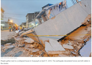 Concepts of Thinking: Spatial Significance, Geographic Perspective, Interrelationships
Inquiry: How might people best help the people who need help? Where might people go to get the aid they need?
Activity: Create a map of the area and the plate boundaries, fault lines and human patterns. Conduct an issue analysis to help determine what could be done. Communicate via story map to the appropriate audience.

Severe drought leaves millions relying on emergency aid
 Concepts of Thinking: Spatial Significance, Interrelationship, Patterns and Trends
Inquiry: What might be the spatial significance of this region that contribute to the drought?
Activity: Gather data on droughts of the region and create a map to help observe patterns and trends. Conduct an issue analysis and add stake holders to the map. Create a story map to communicate results.

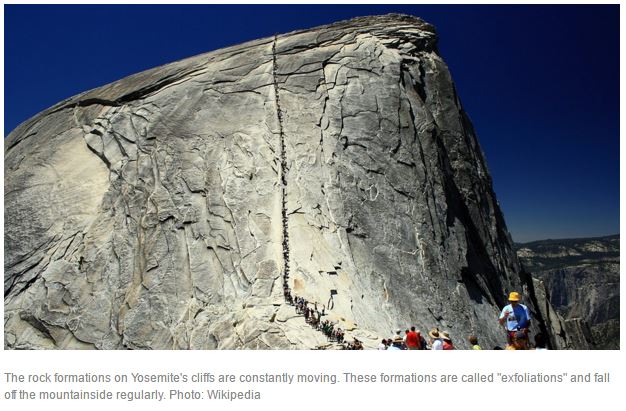
Yosemite's granite cliffs "breathe" and study finds heat can make them fall By 04.05.16
 Concepts of Thinking: Interrelationships, Spatial Significance, Patterns and Trends
Inquiry: What might be some of the contributing factors causing these rock formations to "breath"? How might this "breathing" impact human activity in and around such locations?
Activity: Create a spatial journal of potential location that have the same spatial significance as the Yosemite granite cliffs. Use the patterns to determine other potential sites. What might need to be done to ensure the safety of people living in and around such rock formations? Communicate result to the appropriate audience via story map
WHAT’S GOING ON IN NAGORNO-KARABAKH? NATIONAL GEOGRAPHIC EDUCATION
 Concepts of Thinking: Spatial Significance. Geographic Perspective, Patterns and Ternds
Inquiry: Why might this conflict going on? Why has this conflict not been widely publicized?
Activity: Complete an issue analysis of the issue. Map out the results to determine any patterns or trends. Communicate your results to an appropriate audience to create change to this situation.

Migrant workers suffer 'appalling treatment' in Qatar World Cup stadiums, says Amnesty
 Concepts of Thinking: Geographic Perspective, Interrelationships, Patterns and Trends
Inquiry: Why are there so many migrant workers working in Qatar? What laws might there be for these migrant workers? How else might migrant workers be protected? Where else might workers be treated this poorly? Who should be responsible for ensure workers safety?
Activity: Collect data on where the migrant workers are coming form to help determine spatial significance by mapping out the data. Use proportional symbols to help better display the data for analysis. Complete an issue analysis to better understand the different views and communicate to an appropriate audience a plan of action to help resolve the situation. i.e. story map.

Immigrants Beat Canadians At Starting Businesses: StatsCan
The Huffington Post Canada | By Jesse Ferreras
 Concepts of Thinking: Geographic Perspective, Patterns and Trends
Inquiry: Why are immigrants beating Canadians at starting businesses? How might this pattern impact the Canadian Economy?
The Huffington Post Canada | By Jesse Ferreras

10 of the best alternative city breaks in Europe By: Will Coldwell
 Concepts of Thinking: Spatial Significance, Patterns and Trends
Inquiry: Why might these locations be considered the top 10 best alternative? What might be Canada's top 10 best alternative cities?
Activity: Create a map of these locations to observe patterns, if any, that appear. Evaluate each location in Europe for its spatial significance. Create a map of Canada, using the same spatial significance, to locate the top 10 alternative cities. How might these cities be advertised to increase awareness of their uniqueness?
 Concepts of Thinking: Spatial Significance, Patterns and Trends
Exploring Humanitarian Law (EHL)
 Concepts of Thinking: Geographic Perspective, Spatial Significance, Interrelationships, Patterns and Trends
Activity: Use this resource to meet Geographic curriculum expectations for wide range of courses.

Mississauga mayor leads charge to raise $5M for Syrian refugees

Concepts of Thinking:
Geographic Perspective
Geography definition: What is Where? Why Care?
Mississauga Mayor Bonnie Crombie, seen here at the Hershey Centre as Malcolm Turner, President of the NBA Development League, looks on, in June wants to see the city do more for refugees.

Chile earthquake: one million people evacuated after 8.3 magnitude quake – live updates
Waves of up to 4.5m high reported in some parts of Chile as tsunami warning issued for Peru, Chile, New Zealand, California and Hawaii
Concepts of Thinking: Spatial Significance, Geographic Perspective, Patterns and Trends

Human Development Indicators UNHDR
This web site is a great resource for comparing countries and their HDR values.

Home » Maps & Cartography » 6 Amazing Global
Agriculture Maps – Farming Visualized
Waves of up to 4.5m high reported in some parts of Chile as tsunami warning issued for Peru, Chile, New Zealand, California and Hawaii
Concepts of Thinking: Spatial Significance, Geographic Perspective, Patterns and Trends
Human Development Indicators UNHDR
This web site is a great resource for comparing countries and their HDR values.
Concepts of Thinking: Spatial Significance, Pattern and Trends, Geographic Perspective

Home » Maps & Cartography » 6 Amazing Global Agriculture Maps – Farming Visualized
Shell oil drilling in Arctic set to get US government permission
Controversial decision expected from US interior secretary likely to spark protests from campaigners against Anglo-Dutch exploration in seas off Alaska
 Geographic Concepts of Thinking: Spatial Significance, Geographic Perspective
Geographic Concepts of Thinking: Spatial Significance, Geographic Perspective
A great resource for
World Issues
A great resource for World Issues
The Shocking Truth About What It Would Cost Walmart If It Paid a Living Wage.
In two minutes, economist Robert Reich completely destroys every possible excuse for Walmart’s low wages…
Click on the link: http://tinyurl.com/qaksn92
Concepts of Thinking: Geographic Perspective, Interrelationships, Patterns and Trends,
This is a nice video as a minds on activity.
Some Strange Things Are Happening to Astronauts Returning to Earth.
White House unveils plan to open Atlantic waters to offshore oil drilling
Move to lease large swaths of ocean along east coast and double down in Gulf of Mexico oddly comes in wake of attacks against right for climate change denial
 This could be a common sight along the Atlantic coast horizon after the Obama administration moved to open a large swath of the Atlantic seaboard to oil drilling. Photograph: Cristobal Garcia/EPA
Concepts of Thinking: Spatial Significance, Geographic Prespective
Todays Front Pages From Around the World
Through a special agreement with more than 2,000 newspapers worldwide, the Newseum displays these front pages each day on its website. The front pages are in their original, unedited form, and some may contain material that is deemed objectionable to some visitors. Discretion is advised. –

Geographic Concepts of Thinking: Geographic Perspective, Spatial Significance, Patterns and Trends, and Interrelationships
This link is a good source for World Issue topics. It may have a limited perspective; however, if may start the inquiry process for students.

Polar bear population worldwide
Also
read an associated article http://tinyurl.com/Polar-Bears-at-Winnipeg-Zoo
The Globe and Mail
Published Sunday, Nov. 23 2014, 9:50 PM EST
Last updated Sunday, Nov. 23 2014, 9:50 PM EST

This is a good resource to address the Geographic Concepts of Thinking, particularly Geographic Perspective and Interrelationship, as well as Spatial Significance.
There are plenty of useful links embedded in the document.
Will
New Climate Treaty Be a Thriller, or Shaggy Dog Story?
·
by Stephen Leahy (Uxbridge, Canada)
·
Monday, November
17, 2014
·
Inter Press Service
UXBRIDGE, Canada,
Nov 17 (IPS) - This December, 195 nations plus the European Union will meet in
Lima for two weeks for the crucial U.N. Conference of the Parties on Climate
Change, known as COP 20. The hope in Lima is to produce the first complete
draft of a new global climate agreement.

Carbon map – which countries are responsible for climate change?
As heads of state from David Cameron to Barack Obama meet in New York for a UN climate summit hosted by Ban Ki-moon, expectations are high for bold commitments on cutting greenhouse gas emissions. Use this interactive, in-depth map to find out who the big polluters are internationally, how China’s emissions have grown stratospherically and see who is most vulnerable to global warming’s impacts. Turn your sound up to hear the introduction to the map
· theguardian.com, Tuesday 23 September 2014 05.00 BST
Click on the Link below for the interactive map.
National Geographic, Mapmaker Interactive.
The tool has pre-made layers that can be added to a base map to be edited, printed, and saved. The platform is very similar to ArcGIS On Line so it works as a nice transitional tool. Mapmaker Interactive is very useful for starting the discussion What is Where? Why There? Why Care? This tool is ideal for all levels of Geography.
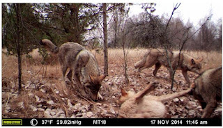
How Wolves Can Alter the Course of Rivers- Video
When wolves were reintroduced to Yellowstone National Park in
the United States after being absent nearly 70 years, the most remarkable
"trophic cascade" occurred. What is a trophic cascade and how exactly
do wolves change rivers? George Monbiot explains in this movie remix titled,
'How Wolves Change Rivers'.


No comments:
Post a Comment