After Hurricane Ida, Oil Infrastructure Springs Dozens of Leaks
By Blacki Migliozzi and
As polar vortex arrives, Canada logs coldest temperature in years.
Brooklyn Neustaeter CTVNews.ca Writer Concepts of Geographic Thinking:
Inquiry: How might the Polar Vortex influence weather across Canada?
Activity: Collect data about Canadian Polar Vortex. Conduct an issue analysis of the polar vortex to determine stakeholders views on the topic. Create a spatial journal to show the location of the polar vortex and create an action plan on how to deal with this weather phenomena and communicate via story map.
Loudspeakers make dead coral reefs sound healthy and fish swim to them By Washington Post, adapted by Newsela staff Published 12/13/2019

Inquiry: How might the fish help bring back the coral to life? What might be required to bring the coral back to life?
Activity: Gather data about coral bleaching and dead coral and create a spatial journal to show where coral is at risk. Collect data on the impacts of coral sounds have on fish. Conduct an issue analysis to understand the different views involved and devise a plan of action to help bring the coral back to life and communicate your results via story map.

Satellites saw rapid Greenland ice loss
BBC news

Inquiry: How might this ice loss impact communities in the north and south? What action to fight climate change might be the best to help reduce this ice loss?
Activity: Gather data on ice loss in Greenland and the results of the ice loss. Create a spatial journal of communities in the region. Conduct an issue analysis to develop an action plan to support communities if current trends continue. Communicate results in a Story Map.

These are the biggest risks facing our world in 2019
World Economic Forum
 Concepts of Geographic Thinking: Interrelationships, Spatial Significance, Patterns and Trends, Geographic Perspective
Inquiry: What might be the solutions to these risks?
Activity: Collect data of Global Risks and create a spatial journal to show where climate issue are most prevalent. Conduct an issue analysis to gain insight into the views of the stakeholders. Determine which issue should take priority and then develop an action plan that can be communicated via story map.

Earth’s magnetic field is acting up and geologists don’t know why

Inquiry: Why might magnetic north be moving? How might the movement of magnetic north
impact communities?
Activity: Gather data on magnetic north movement and map in a spatial journal to determine
any patterns. Conduct an issue analysis to help determine how different stakeholders might be
impacted from this shift. Create a story map to communicate what might happen as the magnetic
field shifts.

New Eye Means Hurricane Florence May Get Stronger Before Slamming into the US
By |

YELLOWSTONE SUPERVOLCANO MAY WAKE UP SOONER THAN WE THOUGHT NATIONAL GEOGRAPHIC 10/16/2017 ·
At least 217 dead after powerful quake hits Mexico – as it happened the guardian
 Concepts of Thinking: Spatial Significance, Geographic Perspective
Inquiry: How might the Mexico City recover?
Activity: Gather data relating to the earthquake and highlight areas impacted. Determine what infrastructure has been effected. Determine how these needs might be addressed. Conduct an issue analysis to determine a plan of action c]and communicate via story map.

Typhoons, cyclones and hurricanes: how these weather systems form
 Concepts of Thinking: Spatial Significance, Patterns and Trends
Inquiry: How might this information be used?
Activity: Gather data on weather systems to help predict where these systems may occur and when. If populations are impacted devise an action plan to support the population. Create a story map to communicate results

A new twist on uranium’s origin story, by CSU scientists
Credit: Amrita Bhattacharyya
 Concepts of Thinking: Spatial Significance, Interrelationships, Geographic Perspective
Inquiry: How might understanding of the origin of Uranium impact mining processes?
Activity: Gather data on uranium mines and how they are managed? Conduct an issue analysis and develop an action plan regarding the mining process. Communicate via story map to an appropriate audience.

Receding glacier causes immense Canadian river to vanish in four days Hannah Devlin
 Concepts of Thinking: Patterns and Trends, Interrelations, Spatial Significance
Inquiry: How might this drastic change impact communities.
Activity: Gather landform data of river basins feed by glaciers. Create models of predicted basin change due to increased glacier melt. Conduct an issue analysis and communicate results to an appropriate audience via story map.
 Concepts of Thinking: Patterns and Trends, Interrelations, Spatial Significance
Flooding More Than Doubled Across Europe in 35 Years By Arthur Neslen, The Guardian
 Concepts of Thinking: Spatial Significance, Patterns and Trends, Interrelationships
Inquiry: How might communities deal with this increase in flooding? What might the next 35 years look like?

NASA spots Tropical Storm Nock-ten intensify
 Concepts of Thinking: Spatial Significance, Interrelationships
Inquiry: What might the impacts be from this storm?
Activity: Gather population data of the region. Conduct an issue analysis relating to the storm. Come up with strategies to deal with the situation and share via story map.
Credit: Credits: NASA MODIS Rapid Response/NOAA

Watch As 15 Years' Worth Of Earthquakes Shake The Planet

Concepts of Thinking: Spatial Significance, Patterns and Trends, Interrelationships,
Inquiry: How might this information be used?
Activity: Gather information on World population and create an annotated map. What are some observations/conclusion that might be made regarding Patterns and Trends and or Interrelationships? Conduct an issue analysis to on the event to determine what might need to be done? Communicate via story map.

Haiti Health Conditions Worsen A Week After Hurricane Matthew
By The Associated Press
 Concepts of Thinking: Spatial Significance, Interrelationship, Geographic Perspective
Inquiry: What might be the best way to meet the needs of Haiti?
Activity: Gather information on Haiti's situation. Conduct an issue analysis to determine how to support Haiti. Communicate results as a story map.

New fault discovered in earthquake-prone Southern California region
Credit: Scripps Institution of Oceanography
 Concepts of Thinking: Spatial Significance, Patterns and Trends
Inquiry: How might this fault line impact the the region.
Activity: Gather data on fault lines in California to create a spatial journal for examining potential interactions with human activities. Communicate possible predictions via story map to an appropriate audience

New study finds major earthquake threat from the Riasi fault in the Himalayas
 Concepts of Thinking: Geographic Perspective, Spatial Significance, Interrelationship
Inquiry: How might a major earthquake impact the Geographic Perspective of the area? How might people of the area prepare for the inevitable?
Activity: Create a spatial journal of earthquakes looking for patterns and trends to establish where vulnerable areas might be. Add population data to aid in the analysis. Create a story map to communicate results.

 Concepts of Thinking: Spatial Significance, Interrelationships, Patterns and Trends
Inquiry: How might be a plausible
Activity: Conduct an issue analysis and map out the data as well as the extent of the bleaching along the Reef. Add to the map human data i.e. distribution, industry etc. Create a story map to communicate your results
 Concepts of Thinking: Spatial Significance, Interrelationships, Patterns and Trends
The Mind-Boggling Scale of Mount Saint Helens's Crater
 Concepts of Thinking: Spatial Significance, Patterns and Trends
Inquiry: When might Mount Saint Helens's have as large an eruption as it did in 1980? What impacts might this new eruption cause?
Activity: Gather information on volcanic eruptions. Create a map of potential location of significant eruptions. Add to this map population data. Communicate to an appropriate audience via story map.

Chilean and Antarctic fossils reveal final "geologic minutes" of dinosaurs
By
 Concepts of Thinking: Spatial Significance, Interrelationships
Inquiry: How might this activity impact the region? If people have to evacuate where might they go? How might they get there?
Activity: Create a map of the region with data such as plate boundaries, volcanoes, population distribution to determine patterns and make predictions.


Peru oil spill pollutes Amazon rivers used by indigenous group BBC
 Concepts of Thinking: Spatial Significance, Interrelationships, Geographic Perspective
Inquiry: Why might oil exploration in such sensitive areas have been approved? Who might be responsible for this spill, the workers? the companies? the consumers? How might this be thoroughly cleaned up?
Activity: Collect data on the spatial significance of the area, plot where it happened, add human activity in the area. Create buffers to determine how far the spill might impact and make predictions.Complete an issue analysis of the problem to determine a possible solution. Communicate predictions and solution in a story map.

9 Deadliest Rocks And Minerals On Earth

Concepts of Thinking: Spatial Significance, Interrelationships
Inquiry: Where might these rocks/mineral be located? Why might might these rocks and minerals be there? How might these rocks and minerals impact human activity?
Activity: Map out the spatial significance of where these rocks and minerals can be found. Add things like soil type, land form type and human activity to enhance the analysis. what might some of the interrelationships be with these rocks and minerals? Create a story map to communicate your results to an appropriate audience.

Prediction of ground motion and dynamic stress change in Baekdusan (Changbaishan) volcano caused by a North Korean nuclear explosion
 Concepts of Thinking: Interrelationships, Spatial Significance
Inquiry: How could a nuclear test contribute to a volcanic eruption
Activity: Analyse data and determine how a nuclear test could cause a volcanic eruptions. Map out other sites that could have similar events occur. Analyse maps to determine who might be impacted and what can be done to help these populations.

Decision on burying nuclear waste near Lake Huron delayed for more study
The Canadian Press
Published Thursday, February 18, 2016
 Concepts of Thinking: Spatial Significance, Geographic Perspective,
Inquiry: How can nuclear waste be disposed of safely? What is where? How is an ideal waste disposal site selected? Why there? If not here then where should the nuclear waste be disposed of? Why Care?
Activity: Collect information on the characteristics of a nuclear waste disposal site i.e. geology of an area and map out using ArcGIS Online. Add to it data such as population, water and other relevant data (dependent on audience). Do an analysis of the map, such as creating buffers, to determine an idea location to dispose of the waste. Complete an issue analysis and the communicate via story map to the appropriate audience.
Exploring Humanitarian Law (EHL)
 Concepts of Thinking: Geographic Perspective, Spatial Significance, Interrelationships, Patterns and Trends
Activity: Use this resource to meet Geographic curriculum expectations for wide range of courses.

Asteroid mining could be space’s new frontier: the problem is doing it legally
 Concepts of Thinking: Geographic Perspective,
Interrelationships
Concepts of Thinking: Geographic Perspective,
Interrelationships
 Concepts of Thinking: Geographic Perspective,
Inquiry: What types of minerals could potential be mined in space? How could it be possible to mine minerals from space? How might these extraterrestrial minerals impact the Global Environment? What might be needed to ensure that mining these minerals is legal?
Activity: Map out where these (the potential extraterrestrial) minerals can be found on earth. Do an issue analysis to determine the positions and possible solutions to this problem. Communicate the best possible solution to the appropriate audience.
Rescuers race to save dozens trapped under rubble of Taiwan earthquake
 Concepts of Thinking: Spatial Significance, Patterns and Trends
Inquiry: Why were the apartments near by the collapsed building not affected to the same extent? How could this collapse have been prevented?

Scientists Discover a New Source of Atmospheric Carbon Dioxide JoAnna Wendel, Staff Writer, Earth & Space News

Concepts of Thinking: Interrelationships, Spatial Significance
Inquiry: Where might the source of CO2 off gassing along the Rift Valley be coming from? What might some human impacts be to this source of CO2?
Activity:
Determine characteristics that are unique to this CO2 type (Why there?)and map out (ArcGIS Online)other locations that could be contributing CO2 in the same manner (What is where?). Add in fault lines, cities, and other data that could be relevant to make predictions (Why care?).
Determine characteristics that are unique to this CO2 type (Why there?)and map out (ArcGIS Online)other locations that could be contributing CO2 in the same manner (What is where?). Add in fault lines, cities, and other data that could be relevant to make predictions (Why care?).
Emergency planners set the stage for "Big One" quake in Pacific Northwest
By 01.28.16
 Concepts of Thinking: Patterns and Trends, Interrelationships, Spatial Significance
Inquiry: What might be the best relocation response be for emergency crew to the "Big One"?
Activity: Gather data to map (ArcGIS Online) out earthquake activity and create buffers to represent the magnitude (How far it can be felt). What is where? Add in data such as plate boundaries to help determine Why there? Add in cities to determine who might be impacted and where possible safe zone may be located. Devise a response plane to the "Big One". Why care?

Earthquakes in Alberta to become more frequent and stronger, expert says
 Concepts of Thinking: Spatial Significance, Patterns and Trends, Interrelationship, Geographic Perspective
Activity Idea: Identify the problem, determine the perspectives (What is where? Why there?), and come up with potential solution for the issue (Why care?). Communicate (including maps) the solution to an appropriate audience.

Fox Creek fracking operation closed indefinitely after earthquake
 Concepts of Thinking: Geographic Perspective, Spatial Significance
Activity Idea: Use ArcGIS Online to create a map of Alberta, near Fox River. Use layers such as fault lines, cities, transportation routes, etc. Place on it the the epicentre and the location of the fracking.
Inquiry Question: How might the fracking activity have contributed to the earthquake near Fox Creek? What might be a solution to the fracking issue?

A new geological epoch, the Anthropocene, has begun, scientists say

Concepts of Thinking: Interrelationships, Patterns and Trends
Activity Idea: Have students create a story map of the Geologic eras with the major characteristic for each to tell the story of the development of the earth. Evaluate the contributing factors of the interrelationships throughout the Geologic time. What might some of the observable patterns and trends be? What might be some predictions that can be made for this information?

Typhoon Nona paralyses central Philippines
 Concepts of Thinking: Interrelationships, Spatial Significance, Patterns and Trends
Inquiry Question: How was this Typhoon so devastating? How could buildings be built to withstand Typhoons? How can people prepare for Typhoons to help reduce the risk/damage?
Activity Idea: Have students use ArcGIS Online or black-line master to create a spatial journal of the Typhoons that have hit this area over the past 10 years. Are there an Patterns that can be observed? How can you account for this pattern?
 Concepts of Thinking: Interrelationships, Spatial Significance, Patterns and Trends
Whale-watching boat tragedy caused by freak wave, say investigators
 Concepts of Thinking: Interrelationships, Spatial Significance
Inquiry questions: What is the spatial significance of the area that could have contributed to the formation of a rogue wave?
Chris McGreal in Tofino

Earthquake rattles remote areas of Afghanistan and Pakistan, at least 263 dead
'Our top priority is to help those affected because of the earthquake,' Pakistani official says
The Associated Press Posted: Oct 26, 2015 5:39 AM ET
Concepts of Thinking: Spatial Significance, Geographic Perspective, Interrelationship
Lesson idea: Map out location of the epicentre and add in communities. Is there any relationship?
Inquiry question: Why might people live in an area that has the potential for such large earthquakes? What might be done to ensure such devastation is minimized in the future?

 Concepts of Thinking: Geographic Perspective, Spatial Significance
Problem Based Learning: What needs to be done to get a video of the Grand Canyon? Why might we want such a video?

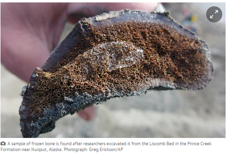
Fossils of new duck-billed, plant-eating dinosaur found in Alaska
Latest finding supports a theory of a ‘lost world of dinosaurs’ that lived in a far cooler climate than most people associated with the creatures

Concepts of Thinking: Spatial Significance
Chile earthquake: one million people evacuated after 8.3 magnitude quake – live updates
Waves of up to 4.5m high reported in some parts of Chile as tsunami warning issued for Peru, Chile, New Zealand, California and Hawaii
Concepts of Thinking: Spatial Significance, Geographic Perspective, Patterns and Trends

Japanese volcano Mount Aso on island of Kyushu erupts
Volcano sends mile-high plume of ash and smoke into the air as power company says the recently restarted Sendai nuclear plant would be unaffected
Concepts of Thinking: Spatial Significance, Geographic Perspective
 Royal Dutch Shell
 Concepts of Thinking:
Geographic Perspective, Interrelationships,
Concepts of Thinking:
Geographic Perspective, Interrelationships,
Part of the Science Museum’s Atmosphere exhibition, which Shell sponsored. Photograph: The Science Museum
An Australian Company Says Its New Extraction Process Could Bring Unlimited Lithium Supplies
Volcano sends mile-high plume of ash and smoke into the air as power company says the recently restarted Sendai nuclear plant would be unaffected
Concepts of Thinking: Spatial Significance, Geographic Perspective
Concepts of Thinking: Spatial Significance, Geographic Perspective
Shell sought to influence direction of Science Museum climate programme
Oil giant raised concerns one part of the project, which it sponsored, could give NGOs opportunity to open up debate on its operations, internal emails show

Concepts of Thinking:
Geographic Perspective, Interrelationships,
Part of the Science Museum’s Atmosphere exhibition, which Shell sponsored. Photograph: The Science Museum
An Australian Company Says Its New Extraction Process Could Bring Unlimited Lithium Supplies
“Micas could eclipse all the other resources currently known.”
http://tinyurl.com/New-Extraction
 Concepts of Thinking: Geographic Perspective, Spatial Significance,
Jason Deign , June 1, 2015
The new coal frontier Galilee Basin, Australia
Can Australia learn from Canada’s Oilsands?
Concepts of Thinking: Geographic Perspective, Spatial Significance,
Jason Deign , June 1, 2015
The new coal frontier
 Galilee Basin, Australia
Global Earthquake Monitor - map & list of recent quakes world-wide
Concepts of Thinking: Spatial Significance

4/30/2015 — VOLCANIC ERUPTION OFF WEST COAST UNITED STATES! OREGON UNDERSEA VOLCANO NOW ERUPTING
Concepts of Thinking: Spatial Significance, Patterns and Trends
Nepal earthquake: Devastation in maps and images 28 April 2015 BBC
Concepts of Thinking: Spatial Significance (why is the earthquake location so important?) Interrelationships (why was it that so many buildings were not livable after the quake?),
Geographic Perspective (how might people be able to best help the situation in Nepal?),
Patterns and Trends (Why would so many people live in an area that has the potential or such damage? What, if any, evidence is there that this may happen again?)
What could be done to ensure that this type of destruction could be reduced in the future?

A series of pictures showing some effects of population increase and the stress on the environment that comes with it.
http://tinyurl.com/effects-of-population-increase

NASA: Global Climate Change, Vital Signs of a Plant
Great slides of Then and Now dealing with Climate Change.
Concepts of Geographic Perspective: Spatial Significance, Patterns and Trends, Interrelationships
Roam the World in (Almost) Real Time
Concepts of Thinking: Geographic Perspective, Spatial Significance
Concepts of Thinking: Spatial Significance, Patterns and Trends

Nepal earthquake: Devastation in maps and images 28 April 2015 BBC
Concepts of Thinking: Spatial Significance (why is the earthquake location so important?) Interrelationships (why was it that so many buildings were not livable after the quake?),
Geographic Perspective (how might people be able to best help the situation in Nepal?),
Patterns and Trends (Why would so many people live in an area that has the potential or such damage? What, if any, evidence is there that this may happen again?)
What could be done to ensure that this type of destruction could be reduced in the future?
The link below has a lot of useful and interesting views of the Earthquake that recently took place in Nepal.
A series of pictures showing some effects of population increase and the stress on the environment that comes with it.
Concepts of Thinking: Spatial Significance, Interrelationships, Geographic Perspective
NASA: Global Climate Change, Vital Signs of a Plant
This sit has many great visuals that related to so many different aspect of the geography curriculum. Two are highlighted below.
Great slides of Then and Now dealing with Climate Change.
Concepts of Geographic Perspective: Spatial Significance, Patterns and Trends, Interrelationships
IMERG Global Precipitation RatesThis visual shows the process of precipitation around the world
Concepts of Geographic Perspective: Spatial Significance, Patterns and Trends
Roam the World in (Almost) Real Time
Cyclone Pam: Vanuatu president says climate change contributed to death and destruction

Baldwin Lonsdale describes category five cyclone Pam as ‘a monster that has hit Vanuatu’, wiping out development.
Concepts of Thinking: Spatial Significance, Geographic Perspective, Interrelationships, Patterns and Trends
Florida banned state workers from using term 'climate change' – report
Global warming’ and ‘sustainability’ among phrases allegedly barred at state’s Department of Environmental Protection, investigative report finds

Florida is threatened by climate change, according to the 2014 US national climate assessment. Photograph: Sipa Press/Rex/Sipa Press/Rex
Geographic Concepts of Thinking: Geographic Perspective, Spatial Significanceby lead poisoning over poverty
AQUEDUCT World Resource Institute
A great resource for World Issues
Concepts of Thinking: Spatial Significance, Patterns and Trends, Interrelationships
Unregulated mining in rural northern Nigeria is causing blindness and paralysis among children and making adults infertile

A stone crusher in Bagega's mining area breaks the rock into pieces to feed to the stone grinder. Dust clys the eyes, nose and mouth. Photograph: Monica Mark
AQUEDUCT World Resource Institute
A great resource for World Issues
Concepts of Thinking: Spatial Significance, Patterns and Trends, Interrelationships
Unregulated mining in rural northern Nigeria is causing blindness and paralysis among children and making adults infertile
British gold mining firm agrees settlement over deaths of Tanzanian villagers
Acacia Mining – formerly African Barrick Gold – has agreed an undisclosed payout over claims that hired police and security guards killed and injured villagers at its North Mara mine in Tanzania

Concepts of Thining: Geographic Perspective, Spatial Significance, Interrelationships, Patterns and Trends
Acacia Mining’s (formerly African Barrick Gold) North Mara mine in Tanzania where villagers were killed and injured at an incident involving police and security guards in 2008. Photograph: Trevor Snapp/Getty Images
This is a nice video as a minds on activity.
Some Strange Things Are Happening to Astronauts Returning to Earth.
Acacia Mining – formerly African Barrick Gold – has agreed an undisclosed payout over claims that hired police and security guards killed and injured villagers at its North Mara mine in Tanzania
Acacia Mining’s (formerly African Barrick Gold) North Mara mine in Tanzania where villagers were killed and injured at an incident involving police and security guards in 2008. Photograph: Trevor Snapp/Getty Images
This is a nice video as a minds on activity.
Todays Front Pages From Around the World

Geographic Concepts of Thinking: Geographic Perspective, Spatial Significance, Patterns and Trends, and Interrelationships
22 Maps of Caanada as you’ve never seen it before
Through a special agreement with more than 2,000 newspapers worldwide, the Newseum displays these front pages each day on its website. The front pages are in their original, unedited form, and some may contain material that is deemed objectionable to some visitors. Discretion is advised. –
Geographic Concepts of Thinking: Geographic Perspective, Spatial Significance, Patterns and Trends, and Interrelationships
22 Maps of Caanada as you’ve never seen it before
This is an interesting article dealing with Greenhouse gases, good for the Environment and Resource Management course.
Concepts of Thinking: Spatial Significance and Patterns and Trends
November 2014: Permafrost soil is possible source of abrupt rise in greenhouse gases at end of last ice age
Bremerhaven, 20 November 2014. Scientists from the Alfred Wegener Institute, Helmholtz Centre for Polar and Marine Research (AWI) have identified a possible source of carbon dioxide (CO2) and other greenhouse gases that were abruptly released to the atmosphere in large quantities around 14,600 years ago.

This link is a good source for World Issue topics. It may have a limited perspective; however, if may start the inquiry process for students.

A good audio recording to address the Geographic Concepts of Thinking, particularly Geographic Perspective
Critics say Keystone Pipeline will keep Canada from hitting 2020 greenhouse gas emissions targets
Canada has committed to cutting its greenhouse gas emissions to 17 per cent below 2005 levels by the year 2020. But with the Keystone XL Pipeline edging closer to approval, some researchers expect a jump in oil sands production will make it impossible to meet the Copenhagen targets.
.jpg)
A good article to address the Geographic Concepts of Thinking, particularly Geographic Perspective and Spatial Significance
Project
seeks to harness – and harvest – the force of Fundy
HALIFAX — The Globe and Mail
Published Sunday, Nov. 16 2014, 10:50 PM EST
Last updated Sunday, Nov. 16 2014, 10:50 PM EST
Five years ago, the Irish
company OpenHydro installed a 10-tonne, multimillion-dollar tidal turbine on
the floor of the Minas Passage – a narrow body of water dominated by the
magnificent basalt cliffs of Cape Split that connects the Minas Basin to the
Bay of Fundy.
This was a historic first in North America and a test to see if
the renowned Fundy tides, known for being the highest in the world, could be
harnessed to produce electricity.

The real story of US coal: inside the world's biggest coalmine
Despite Obama’s pledge to cut carbon emissions, production at North
Antelope Rochelle mine in Wyoming is booming - and climate change is off the
agenda. Suzanne Goldenberg gets a rare look inside the biggest coal mine in the
world
Report by Suzanne
Goldenberg and video by Mae Ryan in North Antelope Rochelle Mine, Wyoming theguardian.com,
Monday 10 November 2014

Watch Iceland’s Bardarbunga volcano exploding - video
Spectacular footage shows explosions at
Bardarbunga volcanic system in Iceland. The footage was taken using a DJI drone
and a GoPro to record activity in the centre of the area's Holuhraun lava
field. The Bardarbunga volcano has been steadily emitting lava for the last
month and the eruption could last for up to a year
Ozone hole layer remains size of North America, Nasa data shows
Antarctic hole in protective layer of gas stands around same level as 2010, 2012 and 2013, but scientists say recovery is on track
This image shows ozone concentrations above Antarctica on 11
September 2014. Photograph: Nasa

Carbon map – which countries are responsible for climate change?
As heads of state from David Cameron to Barack Obama meet in New York for a UN climate summit hosted by Ban Ki-moon, expectations are high for bold commitments on cutting greenhouse gas emissions. Use this interactive, in-depth map to find out who the big polluters are internationally, how China’s emissions have grown stratospherically and see who is most vulnerable to global warming’s impacts. Turn your sound up to hear the introduction to the map
· theguardian.com, Tuesday 23 September 2014 05.00 BST
Click on the Link below for the interactive map.
From the Council of Canadians:
Animated video highlights Energy East threats to Canadian waterways and climate
The link below is an interesting video of some possible problems of new pipeline development in Canada.
National Geographic, Mapmaker Interactive.
The tool has pre-made layers that can be added to a base map to be edited, printed, and saved. The platform is very similar to ArcGIS On Line so it works as a nice transitional tool. Mapmaker Interactive is very useful for starting the discussion What is Where? Why There? Why Care? This tool is ideal for all levels of Geography.
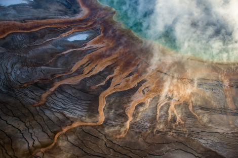
Canada’s oil sands
The Economist Sep 6th 2014
The steam from below
New technologies are being used to extract bitumen from oil sands

How Wolves Can Alter the Course of Rivers- Video
When wolves were reintroduced to Yellowstone National Park in the United States after being absent nearly 70 years, the most remarkable "trophic cascade" occurred. What is a trophic cascade and how exactly do wolves change rivers? George Monbiot explains in this movie remix titled, 'How Wolves Change Rivers'.


No comments:
Post a Comment