Friday 29 April 2016

Great Barrier Reef bleaching made 175 times likelier by human-caused climate change, say scientists 

Concepts of Thinking: Spatial Significance, Interrelationships, Patterns and Trends

Inquiry: How might be a plausible
way of reducing the human impact?

Activity: Conduct an issue analysis and map out the data as well as the extent of the bleaching along the Reef. Add to the map human data i.e. distribution, industry etc. Create a story map to communicate your results

Why being a vegetarian traveller is often so hard to swallow 

Concepts of Thinking: Spatial Significance, Patterns and Trends

Inquiry: How might a vegetarian traveller best meet their needs?

Activity: Research where vegetarianism is most common. Create a chloropleth map to communicate research findings. Add other travel information to map such as tourist attractions to determine the best places for travelers to visit and have quality vegetarian meals.

Thursday 28 April 2016

Canadian waters getting safer, but research gaps limit full understanding of shipping risks

Concepts of Thinking: Spatial Significance, Geographic Perspective, Patterns and Trends, Interrelationship

Inquiry: What might be needed to better understand the shipping risk?

Activity: Conduct an issue analysis. Create a map of the stakeholders to help develop a solution. Create a story map showing a possible solutions to reduce shipping risks in Canadian waters.

Do fracking activities cause earthquakes? Seismologists and the state of Oklahoma say yes By Terry Reith and Briar Stewart, CBC News

Concepts of Thinking: Spatial Significance, Patterns and Trends, Geographic Perspective

Inquiry: How could Fracking contribute to earthquakes

Activity: Create a map of where fracking is taking place. Add to it data about where earthquake epicentres are located as well as population information. Observe any patterns that may have appeared. Gather other information on fracking.  Decide weather fracking can contribute to earthquakes or not. Create a story map to communicate to an appropriate audience a solution to the situation.

Wednesday 27 April 2016

Arctic Cruises Are Extinction Tourism By Another Name  

Concepts of Thinking: Geographic Perspective, Spatial Significance, Patterns and Trends, Interrelationship

Inquiry: How might tourist enjoy the Arctic without destroying it? What have been solutions in other similar situations? Could these solutions work for the the Arctic?

Activity: Map out the areas of greatest impact. Conduct an issue analysis and add to map the stakeholders. Determine a best fit solution and communicate to an appropriate audience via story map.

Brazil swine flu: H1N1 vaccinations to begin as virus kills 230 BBC

Concepts of Thinking: Interrelationship, Patterns and Trends, Spatial Significance,

Inquiry: Where did this virus originate from?How might this virus be prevented, stopped from spreading? Where might this virus move to?

Activity: Create a map of the areas that are affected, past and present. Determine the spatial significance that contribute to the movement of the virus. Make predictions as to where the virus could move to. How might geographic perspective contribute to how the virus could be dealt with. Communicate result to an appropriate audience via story map.

Monday 25 April 2016

Brazil Amazon dam project suspended over concerns for indigenous people 

 in Rio de Janeiro

Concepts of Thinking: Geographic Perspective, Spatial Significance, Patterns and Trends, Interrelationships

Inquiry: How might the Brasil now meet their energy needs? How might other countries show they listen to the concerns of their indigenous people?

Activity: Create an energy map of Brasil, generation and distribution. Conduct an issue analysis. Determine an alternative energy source and communicate to an appropriate audience.

Hunger Map 2015   World Food Programme

Concepts of Thinking: Spatial Significance, Patterns and Trends, Geographic Perspective

Inquiry: In a world that is able to produce a surplus of food why are people still allowed to go hungry? How might a countries hunger rating change if only looking at domestic data (Canada as an example)?

Activity: Determine the stakeholder and conduct an issue analysis. Create flow map of the distribution of food. Add to the the flow of resource and aid countries around the world are involved in. Other data.  Do any patterns appear? What might be some conclusions that can be made about food scarcity and Geographic Perspective and or Spatial significance? Communicate results to an appropriate audience via story map.


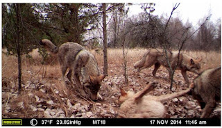
30 years after Chernobyl, UGA camera study reveals wildlife abundance in CEZ

  
Concepts of Thinking: Spatial Significance, Interrelationships, Patterns and Trends

Inquiry: How have these animals been able to survive with the increased levels of radiation in their habitat? How likely is I that humans will be able to thrive with the increased radiation rates?

Activity: Map the Chernobyl nuclear power plant location. Determine level of contamination by creating buffers to show the range of contamination. Add population data and other relevant data to make predictions for how long before the land might be safe for people to go back to a "regular" routine in the area.
Additional info

Friday 22 April 2016


Diesel cars' emissions far higher on road than in lab, tests show  and 
Concepts of Thinking: Spatial Significance, Patterns and Trends, Geographic Perspective

Inquiry: What might some of the consequences be to these increase levels? Where might these impacts be felt the most?

Activity: Create a map of the regions of the world that have diesel cars on the road. Add to the map air quality data and human patterns. Make some predictions of environmental impacts. Communicate to an appropriate audience via story map.
Receding ice causing longer swims for polar bears 

Posted by  in Wildlife on Tuesday, April 19, 2016


Concepts of Thinking: Spatial Significance, Patterns and Trends, interrelationships

Inquiry: How might the increased swim distance impact the polar bears sustainability?

Activity: Create a map of the past and current range of Arctic Ice, polar bear bear range and any other potential contributing factor. Make predictions as to how far the polar bears may have to swim in the future and determine the impact. Communicate to an appropriate audience possible solutions to this problem via story map.

RIDDLE OF THE RED DEER by 

Concepts of Thinking: Interrelationship, Spatial Significance, Patterns and Trends

Inquiry: How might the Red Deer get to the Scottish High Lands? 

Activity: Gather data on the red deer and create a map of their range. Incorporate glacier data  and other data that might have played a role in the migration of the red deer. Create a story map of the journey of the red deer that supports a theory of how the red deer came to Scotland.

Thursday 21 April 2016

Chilean and Antarctic fossils reveal final "geologic minutes" of dinosaurs 

By Ángela Posada-Swafford, Scientific American


Concepts of Thinking: Spatial Significance, Patterns and Trends

Inquiry: Why might it be important to know when the continents were joined? How might knowing when the continents separated impact human activity?

Activity: Create a story map showing the process of continental drift. Research what was happening (physical geography) during the timeline created. Conduct an issue analysis to make some predictions as to what humans may be able to take away with this new knowledge.

Wednesday 20 April 2016


Why won’t the British government recognise Isis atrocities as genocide

Concepts of Thinking: Geographic Perspective, Interrelationships

Inquiry: How might calling the ISIS atrocities a Genocide change how governments of the world treat the situation? How might Canada's government view the issue?

 Activity: Create a map of the areas that are under ISIS control. Conduct an issue analysis to determine what might the best solution be to deal with ISIS. Use a story map to communicate your results to an appropriate audience.

Study finds moose are on the move as the north warms  Posted by  in Wildlife
Concepts of Thinking: Spatial Significance, Patterns and Trends, Interrelationship

Inquiry: What might some impacts be to the environment the moose are moving into and the environments the moose are leaving?

Activity: Create a spatial journal outlining the historical moose habitat. Determine the spatial significance of these areas. Using climate change data, make predictions how these spatial significant habitats may change.

How Geography Impacts Flu Outbreaks by  National Geographic


Concepts of Thinking: Spatial Significance, Interrelationships, Patterns and Trends


Inquiry: How might Doctors be able to use Geography to manage flu or other illnesses?

Activity: Create a map of resent disease (zika virus) outbreaks to help identify patterns and trends. What might be the spatial significance of these areas? Make predictions on where the virus  may move to. Communicate results to an appropriate audience via story map.

Monday 18 April 2016

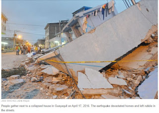
Photos From Ecuador Show Devastation After The Deadly Earthquake

Concepts of Thinking: Spatial Significance, Geographic Perspective, Interrelationships

Inquiry: How might people best help the people who need help? Where might people go to get the aid they need?

Activity: Create a map of the area and the plate boundaries, fault lines and human patterns. Conduct an issue analysis to help determine what could be done. Communicate via story map to the appropriate audience.

Friday 15 April 2016

Governor wants to change, but not scrap, North Carolina law 

By Gary D. Robertson and Jonathan Drew, Associated Press

Concepts of Thinking: Interrelationships, Spatial Significance

Inquiry: Why might a government what discriminatory laws? How might the laws be change to be inclusive?

Activity: Conduct an issue analysis and map out the stakeholders. What are the patterns and trends of the analysis? Create a story map to communicate to the appropriate audience potential solution to the issue show how to bring about change.

Thursday 14 April 2016

Severe drought leaves millions relying on emergency aid

Concepts of Thinking: Spatial Significance, Interrelationship, Patterns and Trends

Inquiry: What might be the spatial significance of this region that contribute to the drought?

Activity: Gather data on droughts of the region and create a map to help observe patterns and trends. Conduct an issue analysis and add stake holders to the map. Create a story map to communicate results.

Boko Haram targets geography teachers By Colin Freeman


Concepts of Thinking:
Geographic Perspective, 

Inquiry: What might some people want to silence another group people?

Activity: Conduct an issue analysis of the situation. Add this information to a map and observe any patterns or trends that may appear. Make predictions on other areas that might go through a similar situation. Try to develop a solution to this situation and communicate to an appropriate audience via story map.

Tuesday 12 April 2016

O.A.G.E.E. Spring Conference
Waterfalls and Parks: Protecting the Niagara Escarpment
Friday May 6, 2016
Dundas Valley, Hamilton, Ontario
See the linked ad for the 2016 Spring Conference in Hamilton on Friday May 6th
  • More information is available at www.oagee.org
  • Check out the pics of the attendees of previous years' conferences. 
  • Online registration will be available shortly. 

Great opportunity to take in the Spatial Significance of Dundas Valley, Hamilton.

Attawapiskat declares state of emergency over spate of suicide attempts By Kate Rutherford, CBC News

Concepts of Thinking: Interrelationships, Patterns and Trends, Spatial Significance, Geographic Perspective

Inquiry: What might the factors be that are contributing to this community having an enormous suicide rate?  What other communities might be facing a similar situation? How might this trend be turned around?

Activity: Create a map to determine the spatial significance of the area. Complete an issue analysis of the problem and and the stakeholders to the map. Communicate potential solution to the appropriate audience via story map.

Monday 11 April 2016

Scientists to resurrect the aurochs, an extinct beast By Jackson Landers, Washington Post

Concepts of Thinking: Interrelationship, Geographic Perspective

Inquiry: What might be the ecological impacts of re-introducing an "extinct" species into an environment?

Activity: Map out the range of this Bull's ancestor. Determine the spatial significance required for this Bull species to thrive. Determine where this spatial significance may be located. Add to it demographic data to determine the feasibility of this animal living in the same spatial significant space.

Farmland prices up 10% last year as property boom spreads to agriculture 

CBC News Posted: Apr 11, 2016 8:47 AM ET

Concepts of Thinking: Spatial Significance, Patterns and Trends, Geographic Perspective

Inquiry: Why might the farmland prices be going up. How does the farmland price increase compare to residential prices? Why might there be a difference?

Activity: Create a spatial journal of houses and farms. Add data such as land use to better discuss the difference. What might the future look like for both type of land use?

Number of tigers in the wild rises for first time in over 100 years Associated Press

Concepts of Thinking: Interrelationship, Patterns and Trends

Inquiry: Why has the Tiger population been able to increase in size over time? How might what happened to the Tigers numbers happen to other species?

Activity: Create a map of the range of the tigers, forested areas, human areas, and other data that is available. Conduct an issue analysis of the issue. If current trends continue how might the landscape look? Make predictions on the tigers plight.

Friday 8 April 2016

Maritime boat building 'boom' fuelled by lobster industry

By Paul Withers, CBC News
Concepts of Thinking: Spatial Significance,
Geographic Perspective, Interrelationships

Inquiry: Why has there been such an "boom" in building lobster boats? What might be the impacts of increased production of lobster boats?

Activity: Gather information and data on lobster "fishing".  Conduct an issue analysis. Create a map of the extent of lobster fishing. Evaluate the human ans environmental impacts of increased lobster fishing to determine proper management of the resource. Communicate results to an appropriate audience via story map.

Massive deforestation found in Brazil’s Cerrado


Concepts of Thinking: Interrelationships, Patterns and Trends, Spatial Significance, Geographic Perspective

Inquiry: How might agriculture in the rain forest be sustainable? 

Activity: Create a map showing the extent of rain forest deforestation over time. Conduct an issue analysis and add these groups to the map. Create a story map to communicate a solution to the problem.

Thursday 7 April 2016

Mekong megadrought erodes food security

Concepts of Thinking: Spatial Significance, Interrelationships, Patterns and Trends

Inquiry: What might be the cause of the drought? Who might be most affected by the drought? What activities might be introduced to prevent such droughts happening in the future?

Activity: Create a spatial journal of the area /river basin indicating the different human activities. Show the extent/range of people who rely on the river basin for food. Identify locations where people may have to go to collect food in the future due to the drought. Communicate possible solutions to help alleviate the situation via story map.

Canada’s oilpatch suffers biggest drop in investment in almost 70 years, CAPP warns  | 

Concepts of Thinking: Patterns and Trends, Spatial Significance, Geographic Perspective, interrelationships

Inquiry: Why might Canada's Oil patch continue to suffer?

Activity: Conduct an issue analysis and map out the stakeholders. Make predictions on the future of Canada's oil industry and Canada's economy. 

Wednesday 6 April 2016

Ontario rescinds controversial proposals to ease wolf and coyote hunting regs in north 

By Gord Ellis, CBC News

Concepts of Thinking: Geographic Perspective, Patterns and Trends, Spatial Significance

Inquiry: How might the hunting of such animals impact human and natural systems.

Activity: Create an issue analysis of of the stakeholders. Create a map of the range of the wolf and coyote populations. Add layers such as cities, different animals, and vegetation etc. Determine what should happen next. Communicate results via a story map.

Turbulent battle as Golden, B.C., fights to save local river rafting industry

Concepts of Thinking: Geographic Perspective, Interrelationship, Spatial Significance, Patterns and Trends

Inquiry: How might rafting company ensure that the increased access will not increase environmental impact?

Activity: Conduct an issue analysis and map out the the stakeholders and the site affected. Determine whether or not permission should be given and communicate to an appropriate audience via story map.

Tuesday 5 April 2016

Candidates compete to become U.N. secretary-general By Julian Borger, The Guardian, adapted by Newsela staff

Concepts of Thinking: Geographic Perspective, Interrelationships

Inquiry: How is the UN secretary-general selected? Why might this role need to change?

Activity: Conduct an issue analysis of the candidates. Create a spatial journal of where the past and present secretary-general and current candidates country of origin. Analyse results for patterns and trends. Make predictions as to who the next secretary-general may be, take in to consideration current world events. Communicate results to an appropriate audience via story map.

Yosemite's granite cliffs "breathe" and study finds heat can make them fall By Los Angeles Times, adapted by Newsela staff 04.05.16

Concepts of Thinking: Interrelationships, Spatial Significance, Patterns and Trends

Inquiry: What might be some of the contributing factors causing these rock formations to "breath"? How might this "breathing" impact human activity in and around such locations?

Activity: Create a spatial journal of potential location that have the same spatial significance as the Yosemite granite cliffs. Use the patterns to determine other potential sites. What might need to be done to ensure the safety of people living in and around such rock formations? Communicate result to the appropriate audience via story map

Top 10 music festivals in Europe for 2016 

Concepts of Thinking: Spatial Significance, Patterns and Trends

Inquiry: What makes an optimal festival location? If the list where to expand to the top 15, where might the next five festivals be located? Why?


Activity: Create a spatial journal of the location to determine a pattern. Is there any part of Europe that is missing? If so what might be needed to fill this space? Communicate results to the appropriate audience via story map.

Monday 4 April 2016

WHAT’S GOING ON IN NAGORNO-KARABAKH? National Geographic Education

Concepts of Thinking: Spatial Significance. Geographic Perspective, Patterns and Ternds

Inquiry: Why might this conflict going on? Why has this conflict not been widely publicized?

Activity: Complete an issue analysis of the issue. Map out the results to determine any patterns or  trends. Communicate your results to an appropriate audience to create change to this situation.

  Welcome to the great ISRAELI REAL ESTATE EVENT Coming to the USA and Canada  https://realestateisrael.org/ Concepts of Thinking:  Geograp...